
Geographic Region: UZBEKISTAN
Feature: S ARAL SEA, ISLAND
|
Geographic Region: UZBEKISTAN Feature: S ARAL SEA, ISLAND |
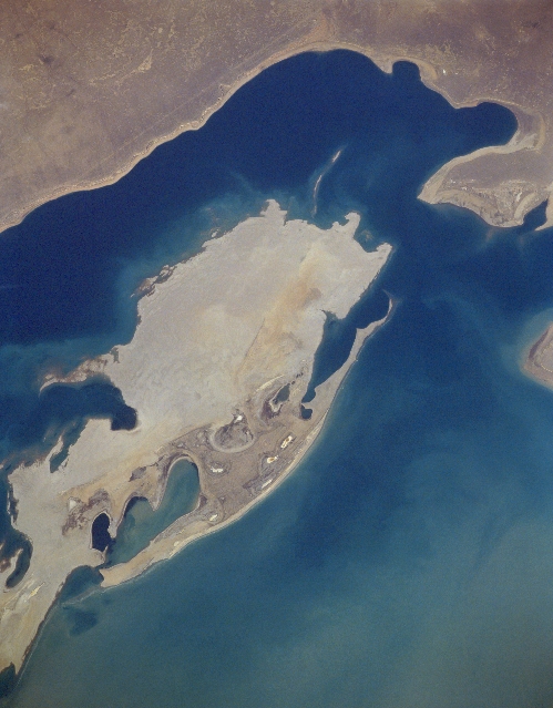 |
| STS066-157-147 Renaissance Island, Uzbekistan November 1994 This near-nadir view shows the ever-expanding Renaissance Island (Vozrozhdeniya Island) as water levels continue to decline in the Aral Sea. Located in the central Aral Sea, Renaissance Island was one of the main laboratories and testing sites for the Former Soviet Union government's Microbiological Warfare Group. It was here, according to just released documents, that the deadly Antrax Virus was developed and stored. The laboratory staff members abandoned the island in late 1991. Many of the containers holding the virus were not properly stored or destroyed, and over the last decade many of the containers have developed leaks. As the Aral Sea continues to recede, the ever-expanding island will eventually connect with the surrounding land. Many scientists fear that reptiles, including snakes, will move to the surrounding land, thus carrying this deadly virus to humans living around and near the shores of the Aral Sea. |
| Images: | All Available Images Low-Resolution 251k |
|
| Mission: | STS066 |
|
| Roll - Frame: | 157 - 147 |
|
| Geographical Name: | UZBEKISTAN |
|
| Features: | S ARAL SEA, ISLAND |
|
| Center Lat x Lon: | 45.0N x 59.5E |
|
| Film Exposure: | N | N=Normal exposure, U=Under exposed, O=Over exposed, F=out of Focus |
| Percentage of Cloud Cover-CLDP: | 0 |
|
| Camera:: | LH |
|
| Camera Tilt: | 11 | LO=Low Oblique, HO=High Oblique, NV=Near Vertical |
| Camera Focal Length: | 250 |
|
| Nadir to Photo Center Direction: | W | The direction from the nadir to the center point, N=North, S=South, E=East, W=West |
| Stereo?: | Y | Y=Yes there is an adjacent picture of the same area, N=No there isn't |
| Orbit Number: | 74 |
|
| Date: | 19941108 | YYYYMMDD |
| Time: | 071719 | GMT HHMMSS |
| Nadir Lat: | 44.9N |
Latitude of suborbital point of spacecraft |
| Nadir Lon: | 60.0E |
Longitude of suborbital point of spacecraft |
| Sun Azimuth: | 173 | Clockwise angle in degrees from north to the sun measured at the nadir point |
| Space Craft Altitude: | 161 | nautical miles |
| Sun Elevation: | 28 | Angle in degrees between the horizon and the sun, measured at the nadir point |
| Land Views: | ISLAND |
|
| Water Views: | SEA |
|
| Atmosphere Views: | |
|
| Man Made Views: | |
|
| City Views: | |
|
Photo is not associated with any sequences | ||
| NASA Home Page |
JSC Home Page |
JSC Digital Image Collection |
Earth Science & Remote Sensing |
|
This service is provided by the International Space Station program and the JSC Earth Science & Remote Sensing Unit, ARES Division, Exploration Integration Science Directorate.

|