
Geographic Region: UZBEKISTAN
Feature: SW ARAL SEA, SEDIMENT
|
Geographic Region: UZBEKISTAN Feature: SW ARAL SEA, SEDIMENT |
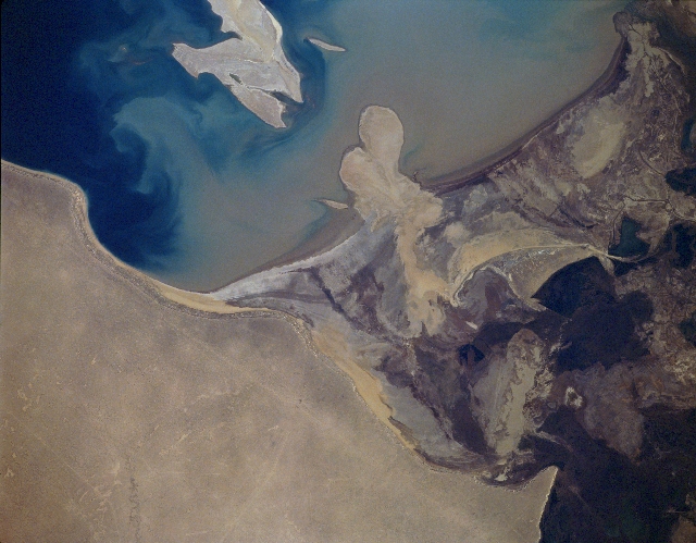 |
| STS066-157-145 Amu-Darya Delta, Uzbekistan November 1994 The Amu-Darya rises in the Pamir Mountains of central Asia and flows 1600 miles (2575 km) before entering the southern Aral Sea through a large delta. The river provides water for irrigation, especially to desert lands to the south of the Aral Sea. These waters from the Amu-Darya flowing into the Aral Sea have been greatly reduced in the last 45 years because of this intensive irrigation. This has caused water levels in the sea to decline thus exposing the delta area as now seen in this image. In the upper right quadrant, the southern portion of Renaissance Island (Vorzrozhdeniya Island) is visible. This island, located in the central Aral Sea, continues to expand as water levels in the sea continue to decline. Renaissance Island was formerly used as the site of the former USSR Government's Microbiological Warfare Group. It was here that the deadly Antrax Virus was developed and stored. As the Aral Sea continues to dry and water levels recede, the ever-expanding island will connect to the surrounding land. Scientists fear that reptiles, including snakes, that have been exposed to the various viruses, will move on to the surrounding land and possibly infect the humans living around the shores of the Aral Sea. |
| Images: | All Available Images Low-Resolution 268k |
|
| Mission: | STS066 |
|
| Roll - Frame: | 157 - 145 |
|
| Geographical Name: | UZBEKISTAN |
|
| Features: | SW ARAL SEA, SEDIMENT |
|
| Center Lat x Lon: | 44.0N x 59.0E |
|
| Film Exposure: | N | N=Normal exposure, U=Under exposed, O=Over exposed, F=out of Focus |
| Percentage of Cloud Cover-CLDP: | 0 |
|
| Camera:: | LH |
|
| Camera Tilt: | 12 | LO=Low Oblique, HO=High Oblique, NV=Near Vertical |
| Camera Focal Length: | 250 |
|
| Nadir to Photo Center Direction: | SW | The direction from the nadir to the center point, N=North, S=South, E=East, W=West |
| Stereo?: | Y | Y=Yes there is an adjacent picture of the same area, N=No there isn't |
| Orbit Number: | 74 |
|
| Date: | 19941108 | YYYYMMDD |
| Time: | 071709 | GMT HHMMSS |
| Nadir Lat: | 44.4N |
Latitude of suborbital point of spacecraft |
| Nadir Lon: | 59.4E |
Longitude of suborbital point of spacecraft |
| Sun Azimuth: | 172 | Clockwise angle in degrees from north to the sun measured at the nadir point |
| Space Craft Altitude: | 161 | nautical miles |
| Sun Elevation: | 29 | Angle in degrees between the horizon and the sun, measured at the nadir point |
| Land Views: | ISLAND, DESERT |
|
| Water Views: | LAKE, DELTA, RIVER |
|
| Atmosphere Views: | |
|
| Man Made Views: | |
|
| City Views: | |
|
Photo is not associated with any sequences | ||
| NASA Home Page |
JSC Home Page |
JSC Digital Image Collection |
Earth Science & Remote Sensing |
|
This service is provided by the International Space Station program and the JSC Earth Science & Remote Sensing Unit, ARES Division, Exploration Integration Science Directorate.

|