Geographic Region: RUSSIAN FEDERATION
Feature: ANGARA RIVER VALLEY
|
Geographic Region: RUSSIAN FEDERATION Feature: ANGARA RIVER VALLEY |
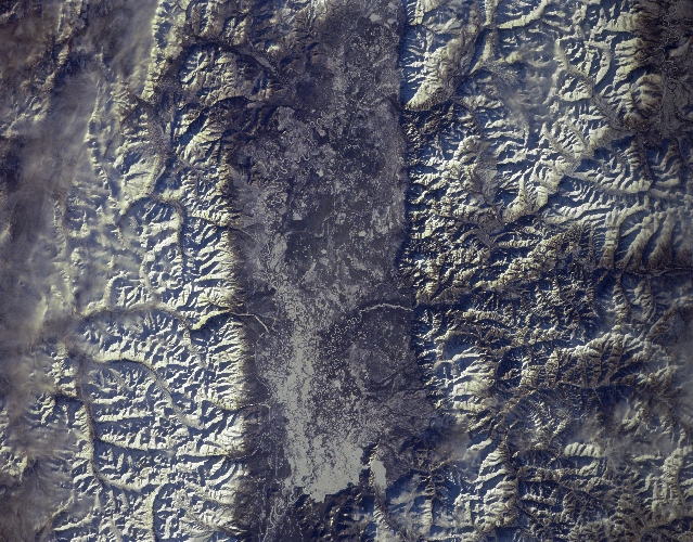 |
| STS066-157-134 Angara River Valley, Russia November 1994 The valley of the Angara River, flanked by the Verkhne Angarsk Range to the north (bottom of image) and the Jkatsk Range to the south (top of image), is visible in this near-nadir view. This view is located to the east of the northern end of Lake Baykal. Snow covers the mountains and the river valley. Though portions of the Angara River Valley are swampy (right center), agricultural products are grown in the river valley during the summer months. Iron, coal, and gold deposits are found in the Angara Basin. |
| Images: | All Available Images Low-Resolution 354k |
|
| Mission: | STS066 |
|
| Roll - Frame: | 157 - 134 |
|
| Geographical Name: | RUSSIAN FEDERATION |
|
| Features: | ANGARA RIVER VALLEY |
|
| Center Lat x Lon: | 56.0N x 111.5E |
|
| Film Exposure: | N | N=Normal exposure, U=Under exposed, O=Over exposed, F=out of Focus |
| Percentage of Cloud Cover-CLDP: | 5 |
|
| Camera:: | LH |
|
| Camera Tilt: | 15 | LO=Low Oblique, HO=High Oblique, NV=Near Vertical |
| Camera Focal Length: | 250 |
|
| Nadir to Photo Center Direction: | NW | The direction from the nadir to the center point, N=North, S=South, E=East, W=West |
| Stereo?: | Y | Y=Yes there is an adjacent picture of the same area, N=No there isn't |
| Orbit Number: | 73 |
|
| Date: | 19941108 | YYYYMMDD |
| Time: | 055225 | GMT HHMMSS |
| Nadir Lat: | 55.6N |
Latitude of suborbital point of spacecraft |
| Nadir Lon: | 112.1E |
Longitude of suborbital point of spacecraft |
| Sun Azimuth: | 204 | Clockwise angle in degrees from north to the sun measured at the nadir point |
| Space Craft Altitude: | 162 | nautical miles |
| Sun Elevation: | 15 | Angle in degrees between the horizon and the sun, measured at the nadir point |
| Land Views: | VALLEY, HILL |
|
| Water Views: | RIVER |
|
| Atmosphere Views: | |
|
| Man Made Views: | |
|
| City Views: | |
|
Photo is not associated with any sequences | ||
| NASA Home Page |
JSC Home Page |
JSC Digital Image Collection |
Earth Science & Remote Sensing |
|
This service is provided by the International Space Station program and the JSC Earth Science & Remote Sensing Unit, ARES Division, Exploration Integration Science Directorate.

|