
Geographic Region: USA-IOWA
Feature: SIOUX CITY, MO. RIVER
|
Geographic Region: USA-IOWA Feature: SIOUX CITY, MO. RIVER |
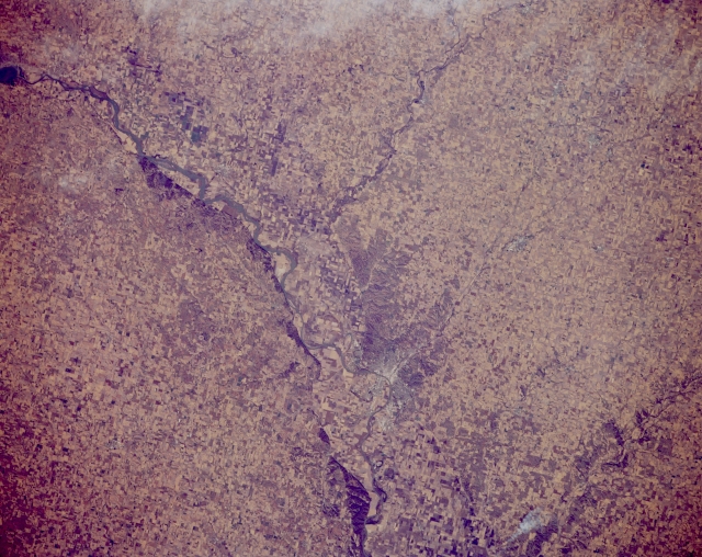 |
| STS066-154-093 Missouri River and Northwestern Iowa, U.S.A. November 1994 The Missouri River and the farmlands of northwestern Iowa and northeastern Nebraska are visible in this north-northeast-looking, low-oblique photograph. Apparent is the Missouri River from the extreme east end of the Lewis and Clark Reservoir on the South Dakota-Nebraska border; its confluence just north of Sioux City with the Big Sioux, which separates Iowa and South Dakota; and its continued path south of Sioux City. Dark tree-covered bluffs rising to 200 feet (61 meters) above the Missouri River Valley floor appear on the east side of the Missouri River. |
| Images: | All Available Images Low-Resolution 319k |
|
| Mission: | STS066 |
|
| Roll - Frame: | 154 - 93 |
|
| Geographical Name: | USA-IOWA |
|
| Features: | SIOUX CITY, MO. RIVER |
|
| Center Lat x Lon: | 42.5N x 96.5W |
|
| Film Exposure: | N | N=Normal exposure, U=Under exposed, O=Over exposed, F=out of Focus |
| Percentage of Cloud Cover-CLDP: | 5 |
|
| Camera:: | LH |
|
| Camera Tilt: | 7 | LO=Low Oblique, HO=High Oblique, NV=Near Vertical |
| Camera Focal Length: | 250 |
|
| Nadir to Photo Center Direction: | S | The direction from the nadir to the center point, N=North, S=South, E=East, W=West |
| Stereo?: | N | Y=Yes there is an adjacent picture of the same area, N=No there isn't |
| Orbit Number: | 65 |
|
| Date: | 19941107 | YYYYMMDD |
| Time: | 174229 | GMT HHMMSS |
| Nadir Lat: | 42.8N |
Latitude of suborbital point of spacecraft |
| Nadir Lon: | 96.4W |
Longitude of suborbital point of spacecraft |
| Sun Azimuth: | 173 | Clockwise angle in degrees from north to the sun measured at the nadir point |
| Space Craft Altitude: | 162 | nautical miles |
| Sun Elevation: | 31 | Angle in degrees between the horizon and the sun, measured at the nadir point |
| Land Views: | PLAIN |
|
| Water Views: | RIVER |
|
| Atmosphere Views: | |
|
| Man Made Views: | AGRICULTURE |
|
| City Views: | |
|
Photo is not associated with any sequences | ||
| NASA Home Page |
JSC Home Page |
JSC Digital Image Collection |
Earth Science & Remote Sensing |
|
This service is provided by the International Space Station program and the JSC Earth Science & Remote Sensing Unit, ARES Division, Exploration Integration Science Directorate.

|