
Geographic Region: USA-GEORGIA
Feature: ATLANTA,L. SYDNEY LANIER
|
Geographic Region: USA-GEORGIA Feature: ATLANTA,L. SYDNEY LANIER |
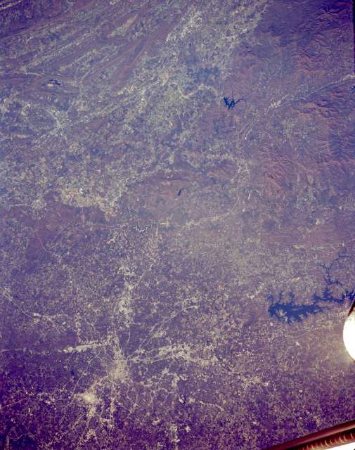 |
| STS066-154-056 Atlanta, Georgia, U.S.A. November 1994 Rapidly developing Atlanta is featured in this synoptic, northwest-looking photograph, which depicts numerous transportation routes radiating from the downtown area. Visible are highly reflective Hartsfield-Atlanta International Airport south of the city and two lakes--irregular-shaped Lake Sidney Lanier to the northeast and smaller Carters Lake to the north. Immediately west of Carters Lake is a north-south-oriented valley between folded ridges (to the west) and the more massive mountains (to the east) of the Appalachian Mountains. Barely discernible north of metropolitan Atlanta is a railroad right-of-way that winds through the valleys of the Blue Ridge Mountains within the Chattahoochee National Forest. |
| Images: | All Available Images Low-Resolution 54k |
|
| Mission: | STS066 |
|
| Roll - Frame: | 154 - 56 |
|
| Geographical Name: | USA-GEORGIA |
|
| Features: | ATLANTA,L. SYDNEY LANIER |
|
| Center Lat x Lon: | 34.0N x 84W |
|
| Film Exposure: | N | N=Normal exposure, U=Under exposed, O=Over exposed, F=out of Focus |
| Percentage of Cloud Cover-CLDP: | 0 |
|
| Camera:: | LH |
|
| Camera Tilt: | 15 | LO=Low Oblique, HO=High Oblique, NV=Near Vertical |
| Camera Focal Length: | 250 |
|
| Nadir to Photo Center Direction: | W | The direction from the nadir to the center point, N=North, S=South, E=East, W=West |
| Stereo?: | Y | Y=Yes there is an adjacent picture of the same area, N=No there isn't |
| Orbit Number: | 64 |
|
| Date: | 19941107 | YYYYMMDD |
| Time: | 160900 | GMT HHMMSS |
| Nadir Lat: | 34.2N |
Latitude of suborbital point of spacecraft |
| Nadir Lon: | 83.3W |
Longitude of suborbital point of spacecraft |
| Sun Azimuth: | 159 | Clockwise angle in degrees from north to the sun measured at the nadir point |
| Space Craft Altitude: | 161 | nautical miles |
| Sun Elevation: | 37 | Angle in degrees between the horizon and the sun, measured at the nadir point |
| Land Views: | MOUNTAIN, VALLEY |
|
| Water Views: | RESERVOIR |
|
| Atmosphere Views: | |
|
| Man Made Views: | URBAN AREA |
|
| City Views: | ATLANTA |
|
Photo is not associated with any sequences | ||
| NASA Home Page |
JSC Home Page |
JSC Digital Image Collection |
Earth Science & Remote Sensing |
|
This service is provided by the International Space Station program and the JSC Earth Science & Remote Sensing Unit, ARES Division, Exploration Integration Science Directorate.

|