
Geographic Region: USA-WISCONSIN
Feature: GREEN BAY,LAKE WINNEBAGO
|
Geographic Region: USA-WISCONSIN Feature: GREEN BAY,LAKE WINNEBAGO |
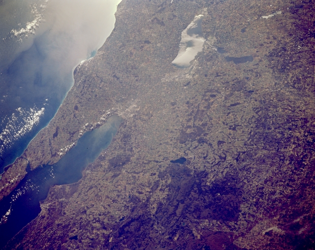 |
| STS066-153-175 Green Bay, Door Peninsula; Lake Winnebago, Wisconsin, U.S.A. November 1994 Featured in this south-southeast-looking, low-oblique photograph are Lake Winnebago, Green Bay, and Door Peninsula in east-central Wisconsin. Green Bay, an arm of Lake Michigan (bottom left), is 100 miles (160 kilometers) long and 10 to 20 miles (16 to 32 kilometers) wide. At its southern end is the city of Green Bay at the mouth of the Fox River, whose sediment plume appears in the southern end of the bay. Southwest of Green Bay lies Lake Winnebago (seen in sunglint), a recreation area 30 miles (48 kilometers) long and 10 miles (16 kilometers) at its widest point. West of Lake Winnebago and Oshkosh is Lake Poygan. Viewing north from Lake Winnebago are Appleton (barely discernible), Shawano Lake, Menominee Indian Reservation, and the Nicolet National Forest. The central plains of Wisconsin are visible along the upper right and right center of the photograph. |
| Images: | All Available Images Low-Resolution 305k |
|
| Mission: | STS066 |
|
| Roll - Frame: | 153 - 175 |
|
| Geographical Name: | USA-WISCONSIN |
|
| Features: | GREEN BAY,LAKE WINNEBAGO |
|
| Center Lat x Lon: | 44.5N x 88.5W |
|
| Film Exposure: | N | N=Normal exposure, U=Under exposed, O=Over exposed, F=out of Focus |
| Percentage of Cloud Cover-CLDP: | 5 |
|
| Camera:: | LH |
|
| Camera Tilt: | 41 | LO=Low Oblique, HO=High Oblique, NV=Near Vertical |
| Camera Focal Length: | 250 |
|
| Nadir to Photo Center Direction: | SE | The direction from the nadir to the center point, N=North, S=South, E=East, W=West |
| Stereo?: | N | Y=Yes there is an adjacent picture of the same area, N=No there isn't |
| Orbit Number: | 112 |
|
| Date: | 19941110 | YYYYMMDD |
| Time: | 163404 | GMT HHMMSS |
| Nadir Lat: | 46.5N |
Latitude of suborbital point of spacecraft |
| Nadir Lon: | 89.6W |
Longitude of suborbital point of spacecraft |
| Sun Azimuth: | 162 | Clockwise angle in degrees from north to the sun measured at the nadir point |
| Space Craft Altitude: | 158 | nautical miles |
| Sun Elevation: | 25 | Angle in degrees between the horizon and the sun, measured at the nadir point |
| Land Views: | PLAIN |
|
| Water Views: | BAY, LAKE, SUNGLINT |
|
| Atmosphere Views: | |
|
| Man Made Views: | |
|
| City Views: | |
|
Photo is not associated with any sequences | ||
| NASA Home Page |
JSC Home Page |
JSC Digital Image Collection |
Earth Science & Remote Sensing |
|
This service is provided by the International Space Station program and the JSC Earth Science & Remote Sensing Unit, ARES Division, Exploration Integration Science Directorate.

|