
Geographic Region: AUSTRALIA-NT
Feature: MACDONNELL RANGES
|
Geographic Region: AUSTRALIA-NT Feature: MACDONNELL RANGES |
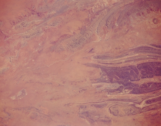 |
| STS066-152-172 Macdonnell Ranges, Northern Territory, Australia November 1994 The Macdonnell Ranges are the gently arching mountains in the upper right of this view. The oval structure immediately south of those ranges is Gosses Bluff, an impact crater. The crater measures 14 miles (22 kilometers) in diameter and is approximately 142 million years old. South of this impact crater are three parallel mountain ranges (from north to south): Gardiner Range, Middle Range (broad dark band, right center), and the George Gill Range. A few isolated low mountains are also visible west-northwest of the Macdonnell Ranges (upper left). Practically all of these mountains are made up of folded sedimentary rocks. Slightly elevated sand plains covered by sparse vegetation and intermontane valleys make up the rest of the landscape in southcentral Northern Territory. |
| Images: | All Available Images Low-Resolution 239k |
|
| Mission: | STS066 |
|
| Roll - Frame: | 152 - 172 |
|
| Geographical Name: | AUSTRALIA-NT |
|
| Features: | MACDONNELL RANGES |
|
| Center Lat x Lon: | 23.5S x 132.0E |
|
| Film Exposure: | N | N=Normal exposure, U=Under exposed, O=Over exposed, F=out of Focus |
| Percentage of Cloud Cover-CLDP: | 0 |
|
| Camera:: | LH |
|
| Camera Tilt: | 11 | LO=Low Oblique, HO=High Oblique, NV=Near Vertical |
| Camera Focal Length: | 90 |
|
| Nadir to Photo Center Direction: | E | The direction from the nadir to the center point, N=North, S=South, E=East, W=West |
| Stereo?: | Y | Y=Yes there is an adjacent picture of the same area, N=No there isn't |
| Orbit Number: | 52 |
|
| Date: | 19941106 | YYYYMMDD |
| Time: | 231618 | GMT HHMMSS |
| Nadir Lat: | 23.5S |
Latitude of suborbital point of spacecraft |
| Nadir Lon: | 131.5E |
Longitude of suborbital point of spacecraft |
| Sun Azimuth: | 93 | Clockwise angle in degrees from north to the sun measured at the nadir point |
| Space Craft Altitude: | 160 | nautical miles |
| Sun Elevation: | 38 | Angle in degrees between the horizon and the sun, measured at the nadir point |
| Land Views: | MOUNTAIN, DESERT, CRATER |
|
| Water Views: | |
|
| Atmosphere Views: | |
|
| Man Made Views: | |
|
| City Views: | |
|
Photo is not associated with any sequences | ||
| NASA Home Page |
JSC Home Page |
JSC Digital Image Collection |
Earth Science & Remote Sensing |
|
This service is provided by the International Space Station program and the JSC Earth Science & Remote Sensing Unit, ARES Division, Exploration Integration Science Directorate.

|