 Photo #: STS066-152-170 Date: Nov. 1994
Geographic Region: AUSTRALIA-NT
Feature: LAKE AMADEUS

 Photo #: STS066-152-170 Date: Nov. 1994 Photo #: STS066-152-170 Date: Nov. 1994Geographic Region: AUSTRALIA-NT Feature: LAKE AMADEUS |
 |
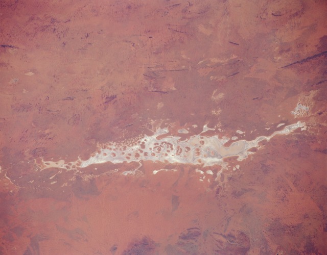
| STS066-152-170 Lake Amadeus, Northern Territory, Australia November 1994 Located in the southwest corner of Northern Territory and near the geographic center of Australia, Lake Amadeus is one of hundreds of ephemeral lakes (called playas) that characterize the desert landscape of central and especially western Australia. When there has been sufficient rainfall, this lake is part of an east-flowing drainage system that eventually connects to the Finke River. Like other ephemeral lakes in central Australia, water quality is "fresh" immediately after it rains but rapidly becomes brackish in a short period of time. Lake Amadeus is a major water discharge area for central Australia, and ground water seeps to the surface around the periphery of the lake. The darker features within the flat plains of the playa (whitish area) are slightly elevated, vegetated islands. Most of the surrounding terrain is covered by sand dunes, sand ridges, and desert vegetation. The length of the lake is approximately 75 miles (120 kilometers). |
| Images: | All Available Images Low-Resolution 71k |
|
| Mission: | STS066 |
|
| Roll - Frame: | 152 - 170 |
|
| Geographical Name: | AUSTRALIA-NT |
|
| Features: | LAKE AMADEUS |
|
| Center Lat x Lon: | 25S x 131.0E |
|
| Film Exposure: | N | N=Normal exposure, U=Under exposed, O=Over exposed, F=out of Focus |
| Percentage of Cloud Cover-CLDP: | 0 |
|
| Camera:: | LH |
|
| Camera Tilt: | 13 | LO=Low Oblique, HO=High Oblique, NV=Near Vertical |
| Camera Focal Length: | 90 |
|
| Nadir to Photo Center Direction: | S | The direction from the nadir to the center point, N=North, S=South, E=East, W=West |
| Stereo?: | Y | Y=Yes there is an adjacent picture of the same area, N=No there isn't |
| Orbit Number: | 52 |
|
| Date: | 19941106 | YYYYMMDD |
| Time: | 231601 | GMT HHMMSS |
| Nadir Lat: | 24.4S |
Latitude of suborbital point of spacecraft |
| Nadir Lon: | 130.8E |
Longitude of suborbital point of spacecraft |
| Sun Azimuth: | 92 | Clockwise angle in degrees from north to the sun measured at the nadir point |
| Space Craft Altitude: | 160 | nautical miles |
| Sun Elevation: | 37 | Angle in degrees between the horizon and the sun, measured at the nadir point |
| Land Views: | DESERT |
|
| Water Views: | PLAYA |
|
| Atmosphere Views: | |
|
| Man Made Views: | |
|
| City Views: | |
|
Photo is not associated with any sequences | ||
| NASA Home Page |
JSC Home Page |
JSC Digital Image Collection |
Earth Science & Remote Sensing |
|
|