
Geographic Region: USA-TEXAS
Feature: NEAR POSSUM KINGDOM L.
|
Geographic Region: USA-TEXAS Feature: NEAR POSSUM KINGDOM L. |
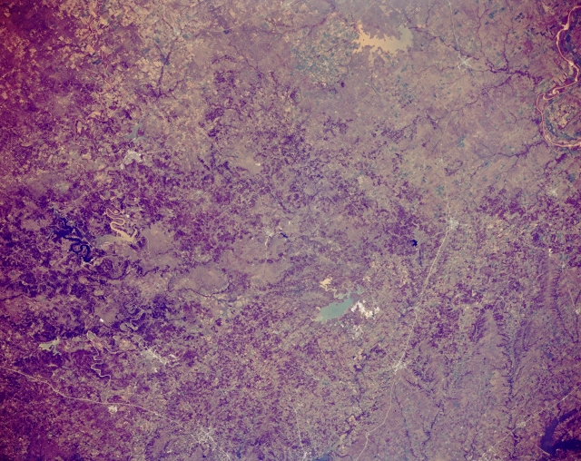 |
| STS066-152-115 Lake Bridgeport, Texas, U.S.A. November 1994 This northwest-looking, panoramic photograph features low plateaus, rolling prairies, and cuestas west and northwest of Fort Worth. Discernible are Decatur, Bowie, and Henrietta along U.S. Highway 287 that connects Fort Worth with Wichita Falls. Two sizable reservoirs, aqua Lake Bridgeport and muddy Lake Arrowhead, lie west of U.S. Highway 287. More difficult to identify southwest of Lake Bridgeport is Possum Kingdom Lake, the northern branch of which appears muddy, while the western section is very dark. East-west-oriented Interstate Highway 20 (bottom left corner) appears south of Weatherford, just west of Fort Worth. A small section of the Red River is visible (upper right corner). |
| Images: | All Available Images Low-Resolution 335k |
|
| Mission: | STS066 |
|
| Roll - Frame: | 152 - 115 |
|
| Geographical Name: | USA-TEXAS |
|
| Features: | NEAR POSSUM KINGDOM L. |
|
| Center Lat x Lon: | 33.0N x 98.5W |
|
| Film Exposure: | N | N=Normal exposure, U=Under exposed, O=Over exposed, F=out of Focus |
| Percentage of Cloud Cover-CLDP: | 0 |
|
| Camera:: | LH |
|
| Camera Tilt: | NV | LO=Low Oblique, HO=High Oblique, NV=Near Vertical |
| Camera Focal Length: | 90 |
|
| Nadir to Photo Center Direction: | The direction from the nadir to the center point, N=North, S=South, E=East, W=West |
|
| Stereo?: | N | Y=Yes there is an adjacent picture of the same area, N=No there isn't |
| Orbit Number: | |
|
| Date: | 199411__ | YYYYMMDD |
| Time: | GMT HHMMSS |
|
| Nadir Lat: | N |
Latitude of suborbital point of spacecraft |
| Nadir Lon: | E |
Longitude of suborbital point of spacecraft |
| Sun Azimuth: | Clockwise angle in degrees from north to the sun measured at the nadir point |
|
| Space Craft Altitude: | nautical miles |
|
| Sun Elevation: | Angle in degrees between the horizon and the sun, measured at the nadir point |
|
| Land Views: | RANGE |
|
| Water Views: | RESERVOIR |
|
| Atmosphere Views: | |
|
| Man Made Views: | HIGHWAY |
|
| City Views: | |
|
Photo is not associated with any sequences | ||
| NASA Home Page |
JSC Home Page |
JSC Digital Image Collection |
Earth Science & Remote Sensing |
|
This service is provided by the International Space Station program and the JSC Earth Science & Remote Sensing Unit, ARES Division, Exploration Integration Science Directorate.

|