
Geographic Region: USA-NEW YORK
Feature: LONG ISLAND, NEW YORK CY
|
Geographic Region: USA-NEW YORK Feature: LONG ISLAND, NEW YORK CY |
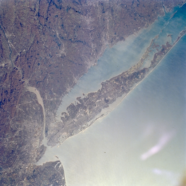 |
| STS066-127-032 Long Island, New York November 1994 The fourth largest island of the United States and the largest outside of Alaska and Hawaii, Long Island can be seen in this northeast-looking view. Long Island is 118 miles (190 km) long, 12 to 20 miles (19 to 32 km) wide, and covers an area of 1723 sq. miles (4463 sq. km). Most of northern Long Island is made up of glacial deposits forming small hills and cliffs and indented bays. The southern portions of Long Island are low-lying out-wash plains of glacial deposits consisting of long sandy beaches, backed by dunes and shallow lagoons. Sand and gravel are quarried from the island's glacial deposits. Commercial fishing and recreation are also important commodities of the island. Long Island Sound, a former river valley, separates Long Island from the southern coast of the state of Connecticut. The New York/Newark Metropolitan areas are discernible extending north to south along the left (western) edge of the image. |
| Images: | All Available Images Low-Resolution 332k |
|
| Mission: | STS066 |
|
| Roll - Frame: | 127 - 32 |
|
| Geographical Name: | USA-NEW YORK |
|
| Features: | LONG ISLAND, NEW YORK CY |
|
| Center Lat x Lon: | 41.0N x 73.5W |
|
| Film Exposure: | N | N=Normal exposure, U=Under exposed, O=Over exposed, F=out of Focus |
| Percentage of Cloud Cover-CLDP: | 0 |
|
| Camera:: | HB |
|
| Camera Tilt: | 29 | LO=Low Oblique, HO=High Oblique, NV=Near Vertical |
| Camera Focal Length: | 100 |
|
| Nadir to Photo Center Direction: | S | The direction from the nadir to the center point, N=North, S=South, E=East, W=West |
| Stereo?: | N | Y=Yes there is an adjacent picture of the same area, N=No there isn't |
| Orbit Number: | 64 |
|
| Date: | 19941107 | YYYYMMDD |
| Time: | 161151 | GMT HHMMSS |
| Nadir Lat: | 42.4N |
Latitude of suborbital point of spacecraft |
| Nadir Lon: | 74W |
Longitude of suborbital point of spacecraft |
| Sun Azimuth: | 172 | Clockwise angle in degrees from north to the sun measured at the nadir point |
| Space Craft Altitude: | 162 | nautical miles |
| Sun Elevation: | 31 | Angle in degrees between the horizon and the sun, measured at the nadir point |
| Land Views: | ISLAND, COAST, FOREST, UPLAND |
|
| Water Views: | BAY, RIVER |
|
| Atmosphere Views: | |
|
| Man Made Views: | URBAN AREA |
|
| City Views: | |
|
Photo is not associated with any sequences | ||
| NASA Home Page |
JSC Home Page |
JSC Digital Image Collection |
Earth Science & Remote Sensing |
|
This service is provided by the International Space Station program and the JSC Earth Science & Remote Sensing Unit, ARES Division, Exploration Integration Science Directorate.

|