
Geographic Region: USA-ALABAMA
Feature: MOBILE, MOBILE BAY, SED.
|
Geographic Region: USA-ALABAMA Feature: MOBILE, MOBILE BAY, SED. |
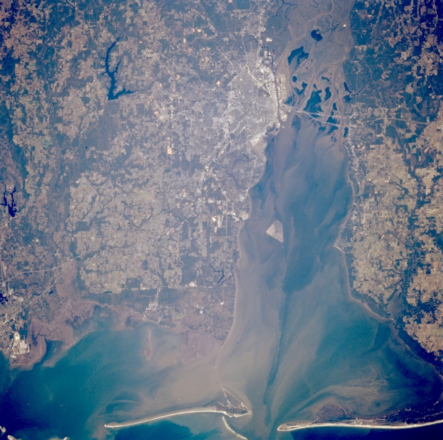 |
| STS066-126-095 Mobile Bay, Alabama, U.S.A. November 1994 Featured in this photograph are the Gulf of Mexico; the port of Mobile at the northwest corner of sediment-laden Mobile Bay; and highly reflective, elongated, sandy beaches of the barrier islands that help to create the east-west-oriented Intracoastal Waterway. The Mobile River, the southern extension of the Tombigbee Waterway System that connects Mobile with Knoxville, Tennessee, has created a sizable delta at the northern end of Mobile Bay. Visible are dark Big Creek Lake west of Mobile; segments of Interstate Highway 10 across the southern end of the delta at the north end of Mobile Bay; and highly reflective, industrialized Moss Point, Mississippi (lower left edge). Apparent are dark vegetated and wooded bottomlands and lighter cultivated fields and pasturelands. |
| Images: | All Available Images Low-Resolution 370k |
|
| Mission: | STS066 |
|
| Roll - Frame: | 126 - 95 |
|
| Geographical Name: | USA-ALABAMA |
|
| Features: | MOBILE, MOBILE BAY, SED. |
|
| Center Lat x Lon: | 30.5N x 88W |
|
| Film Exposure: | N | N=Normal exposure, U=Under exposed, O=Over exposed, F=out of Focus |
| Percentage of Cloud Cover-CLDP: | 0 |
|
| Camera:: | HB |
|
| Camera Tilt: | LO | LO=Low Oblique, HO=High Oblique, NV=Near Vertical |
| Camera Focal Length: | 250 |
|
| Nadir to Photo Center Direction: | The direction from the nadir to the center point, N=North, S=South, E=East, W=West |
|
| Stereo?: | Y | Y=Yes there is an adjacent picture of the same area, N=No there isn't |
| Orbit Number: | |
|
| Date: | 199411__ | YYYYMMDD |
| Time: | GMT HHMMSS |
|
| Nadir Lat: | N |
Latitude of suborbital point of spacecraft |
| Nadir Lon: | E |
Longitude of suborbital point of spacecraft |
| Sun Azimuth: | Clockwise angle in degrees from north to the sun measured at the nadir point |
|
| Space Craft Altitude: | nautical miles |
|
| Sun Elevation: | Angle in degrees between the horizon and the sun, measured at the nadir point |
|
| Land Views: | PLAIN |
|
| Water Views: | BAY, DELTA, SEDIMENT, RESERVOIR |
|
| Atmosphere Views: | |
|
| Man Made Views: | URBAN AREA, HIGHWAY |
|
| City Views: | |
|
Photo is not associated with any sequences | ||
| NASA Home Page |
JSC Home Page |
JSC Digital Image Collection |
Earth Science & Remote Sensing |
|
This service is provided by the International Space Station program and the JSC Earth Science & Remote Sensing Unit, ARES Division, Exploration Integration Science Directorate.

|