
Geographic Region: USA-MICHIGAN
Feature: DETROIT, L. ST. CLAIR
|
Geographic Region: USA-MICHIGAN Feature: DETROIT, L. ST. CLAIR |
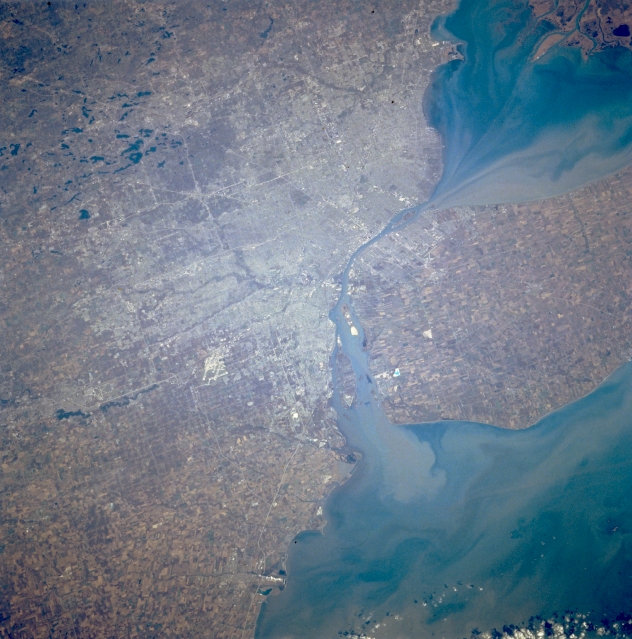 |
| STS066-124-067 Detroit, Michigan, U.S.A. November 1994 Detroit, the "automobile capital of the world," lies west of Lake Saint Clair and the Detroit River in this north-looking, low-oblique photograph. The largest city in Michigan, Detroit is a port of entry; a major Great Lakes shipping and rail center; and a major industrial, commercial, financial, and cultural center for the region. Detroit leads the nation in the production of gray iron foundry products, metal stampings, and machine tools. Extensive salt mines underlie the southwestern section of the city. Visible are the runways of Detroit Metropolitan Wayne County Airport (left of center) west of the Detroit River; numerous small lakes northwest of the city; Lake Saint Clair (upper right); and Lake Erie (bottom right). Windsor, Ontario, Canada, is discernible (near center) east of the Detroit River. |
| Images: | All Available Images Low-Resolution 341k |
|
| Mission: | STS066 |
|
| Roll - Frame: | 124 - 67 |
|
| Geographical Name: | USA-MICHIGAN |
|
| Features: | DETROIT, L. ST. CLAIR |
|
| Center Lat x Lon: | 42.5N x 83.5W |
|
| Film Exposure: | N | N=Normal exposure, U=Under exposed, O=Over exposed, F=out of Focus |
| Percentage of Cloud Cover-CLDP: | 5 |
|
| Camera:: | HB |
|
| Camera Tilt: | LO | LO=Low Oblique, HO=High Oblique, NV=Near Vertical |
| Camera Focal Length: | 100 |
|
| Nadir to Photo Center Direction: | The direction from the nadir to the center point, N=North, S=South, E=East, W=West |
|
| Stereo?: | Y | Y=Yes there is an adjacent picture of the same area, N=No there isn't |
| Orbit Number: | |
|
| Date: | 199411__ | YYYYMMDD |
| Time: | GMT HHMMSS |
|
| Nadir Lat: | N |
Latitude of suborbital point of spacecraft |
| Nadir Lon: | E |
Longitude of suborbital point of spacecraft |
| Sun Azimuth: | Clockwise angle in degrees from north to the sun measured at the nadir point |
|
| Space Craft Altitude: | nautical miles |
|
| Sun Elevation: | Angle in degrees between the horizon and the sun, measured at the nadir point |
|
| Land Views: | |
|
| Water Views: | LAKE, SEDIMENT, RIVER |
|
| Atmosphere Views: | |
|
| Man Made Views: | URBAN AREA, AGRICULTURE, AIRPORT |
|
| City Views: | DETROIT |
|
Photo is not associated with any sequences | ||
| NASA Home Page |
JSC Home Page |
JSC Digital Image Collection |
Earth Science & Remote Sensing |
|
This service is provided by the International Space Station program and the JSC Earth Science & Remote Sensing Unit, ARES Division, Exploration Integration Science Directorate.

|