
Geographic Region: USA-NEBRASKA
Feature: OMAHA, MISSOURI R., AGR.
|
Geographic Region: USA-NEBRASKA Feature: OMAHA, MISSOURI R., AGR. |
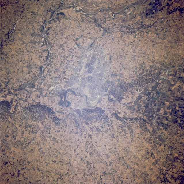 |
| STS066-124-045 Omaha, Nebraska, and Council Bluffs, Iowa, U.S.A. November 1994 Situated in the heart of the United States farming and agricultural region, the cities of Omaha, Nebraska, and Council Bluffs, Iowa, are evident in this west-southwest-looking, low-oblique photograph. Visible is the south-flowing Platte River as it turns eastward to join the south-flowing Missouri River 20 miles (32 kilometers) south of Omaha, one of the largest livestock markets and meat processing centers in the world. Apparent midway between Omaha and the Platte River are the runways of Offutt Air Force Base, the headquarters of the U.S. Air Force Strategic Air Command. |
| Images: | All Available Images Low-Resolution 395k |
|
| Mission: | STS066 |
|
| Roll - Frame: | 124 - 45 |
|
| Geographical Name: | USA-NEBRASKA |
|
| Features: | OMAHA, MISSOURI R., AGR. |
|
| Center Lat x Lon: | 41.5N x 96W |
|
| Film Exposure: | N | N=Normal exposure, U=Under exposed, O=Over exposed, F=out of Focus |
| Percentage of Cloud Cover-CLDP: | 0 |
|
| Camera:: | HB |
|
| Camera Tilt: | 23 | LO=Low Oblique, HO=High Oblique, NV=Near Vertical |
| Camera Focal Length: | 100 |
|
| Nadir to Photo Center Direction: | S | The direction from the nadir to the center point, N=North, S=South, E=East, W=West |
| Stereo?: | N | Y=Yes there is an adjacent picture of the same area, N=No there isn't |
| Orbit Number: | 112 |
|
| Date: | 19941110 | YYYYMMDD |
| Time: | 163230 | GMT HHMMSS |
| Nadir Lat: | 42.6N |
Latitude of suborbital point of spacecraft |
| Nadir Lon: | 95.8W |
Longitude of suborbital point of spacecraft |
| Sun Azimuth: | 155 | Clockwise angle in degrees from north to the sun measured at the nadir point |
| Space Craft Altitude: | 158 | nautical miles |
| Sun Elevation: | 27 | Angle in degrees between the horizon and the sun, measured at the nadir point |
| Land Views: | PLAIN |
|
| Water Views: | RIVER |
|
| Atmosphere Views: | |
|
| Man Made Views: | URBAN AREA, AGRICULTURE |
|
| City Views: | COUNCIL BLUFFS, OMAHA |
|
Photo is not associated with any sequences | ||
| NASA Home Page |
JSC Home Page |
JSC Digital Image Collection |
Earth Science & Remote Sensing |
|
This service is provided by the International Space Station program and the JSC Earth Science & Remote Sensing Unit, ARES Division, Exploration Integration Science Directorate.

|