
Geographic Region: AUSTRALIA-Q
Feature: HAMILTON RIVER, BURKE R.
|
Geographic Region: AUSTRALIA-Q Feature: HAMILTON RIVER, BURKE R. |
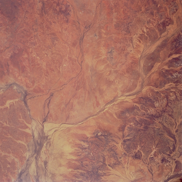 |
| STS066-119-094 Hamilton River, Queensland, Australia November 1994 Three ephemeral rivers converge (lower left) in the area of southwestern Queensland seen here. The winding, multi-channeled Hamilton River (right middle) flows southwestward and the Burke River (upper middle), with its less developed floodplain, flows southward to join the Georgina River. South of the confluence the floodplain of the Georgina River widens dramatically. The headwaters of the Georgina River are about 190 miles (300 kilometers) west of the Selwyn Range in the Barkly Tableland; while the headwaters of the Burke River and Willis Creek (the western stream in the confluence in upper center of picture) are in the Cloncurry Plateau, just south of the Mount Isa silver mines. The Finucane Range (lower right one-third of view) forms the divide between the major Georgina (west) and Diamantina (east) drainages. The drainage patterns of these rivers are easily recognized and differentiated from the arid, desert landscape due to their darker features--caused either by increased vegetation or traces of moisture in the numerous channels. |
| Images: | All Available Images Low-Resolution 316k |
|
| Mission: | STS066 |
|
| Roll - Frame: | 119 - 94 |
|
| Geographical Name: | AUSTRALIA-Q |
|
| Features: | HAMILTON RIVER, BURKE R. |
|
| Center Lat x Lon: | 23S x 140.0E |
|
| Film Exposure: | N | N=Normal exposure, U=Under exposed, O=Over exposed, F=out of Focus |
| Percentage of Cloud Cover-CLDP: | 0 |
|
| Camera:: | HB |
|
| Camera Tilt: | 27 | LO=Low Oblique, HO=High Oblique, NV=Near Vertical |
| Camera Focal Length: | 100 |
|
| Nadir to Photo Center Direction: | S | The direction from the nadir to the center point, N=North, S=South, E=East, W=West |
| Stereo?: | Y | Y=Yes there is an adjacent picture of the same area, N=No there isn't |
| Orbit Number: | 36 |
|
| Date: | 19941105 | YYYYMMDD |
| Time: | 230841 | GMT HHMMSS |
| Nadir Lat: | 21.7S |
Latitude of suborbital point of spacecraft |
| Nadir Lon: | 140.4E |
Longitude of suborbital point of spacecraft |
| Sun Azimuth: | 91 | Clockwise angle in degrees from north to the sun measured at the nadir point |
| Space Craft Altitude: | 161 | nautical miles |
| Sun Elevation: | 44 | Angle in degrees between the horizon and the sun, measured at the nadir point |
| Land Views: | BASIN, FLOOD PLAIN |
|
| Water Views: | RIVER |
|
| Atmosphere Views: | |
|
| Man Made Views: | |
|
| City Views: | |
|
Photo is not associated with any sequences | ||
| NASA Home Page |
JSC Home Page |
JSC Digital Image Collection |
Earth Science & Remote Sensing |
|
This service is provided by the International Space Station program and the JSC Earth Science & Remote Sensing Unit, ARES Division, Exploration Integration Science Directorate.

|