
Geographic Region: AUSTRALIA-Q
Feature: SIMPSON DES., EYRE CREEK
|
Geographic Region: AUSTRALIA-Q Feature: SIMPSON DES., EYRE CREEK |
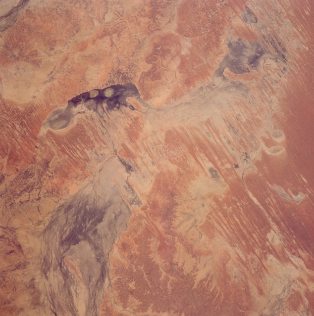 |
| STS066-119-090 Eyre Creek, Queensland, Australia November 1994 A complex interior drainage pattern of Eyre Creek marks the arid transition zone between the Great Artesian Basin and the northeastern fringe of the Simpson Desert in southwest Queensland. The water flow in Eyre Creek is actually from north (bottom left) to south where it enters a depression. After passing through the ephemeral "lagoon" (darker feature) the creek makes a ninety-degree turn to the west, eventually ending up in another shallow depression (darker feature--upper right). The darker areas within the multi-braided ephemeral stream channels show where the lower lying areas are located within the slope of the landscape. These ephemeral "lagoons" are darker because of plant growth or fungus and in some cases moisture is present in the depressions. The alternating light and dark, paralleling lines are a series of sand dunes, generally oriented north-south. |
| Images: | All Available Images Low-Resolution 310k |
|
| Mission: | STS066 |
|
| Roll - Frame: | 119 - 90 |
|
| Geographical Name: | AUSTRALIA-Q |
|
| Features: | SIMPSON DES., EYRE CREEK |
|
| Center Lat x Lon: | 24.5S x 139.5E |
|
| Film Exposure: | N | N=Normal exposure, U=Under exposed, O=Over exposed, F=out of Focus |
| Percentage of Cloud Cover-CLDP: | 0 |
|
| Camera:: | HB |
|
| Camera Tilt: | 19 | LO=Low Oblique, HO=High Oblique, NV=Near Vertical |
| Camera Focal Length: | 100 |
|
| Nadir to Photo Center Direction: | SE | The direction from the nadir to the center point, N=North, S=South, E=East, W=West |
| Stereo?: | Y | Y=Yes there is an adjacent picture of the same area, N=No there isn't |
| Orbit Number: | 36 |
|
| Date: | 19941105 | YYYYMMDD |
| Time: | 230805 | GMT HHMMSS |
| Nadir Lat: | 23.7S |
Latitude of suborbital point of spacecraft |
| Nadir Lon: | 139.0E |
Longitude of suborbital point of spacecraft |
| Sun Azimuth: | 90 | Clockwise angle in degrees from north to the sun measured at the nadir point |
| Space Craft Altitude: | 161 | nautical miles |
| Sun Elevation: | 43 | Angle in degrees between the horizon and the sun, measured at the nadir point |
| Land Views: | DESERT, BASIN |
|
| Water Views: | RIVER |
|
| Atmosphere Views: | |
|
| Man Made Views: | |
|
| City Views: | |
|
Photo is not associated with any sequences | ||
| NASA Home Page |
JSC Home Page |
JSC Digital Image Collection |
Earth Science & Remote Sensing |
|
This service is provided by the International Space Station program and the JSC Earth Science & Remote Sensing Unit, ARES Division, Exploration Integration Science Directorate.

|