Geographic Region: TANZANIA
Feature: KILIMANJARO, AGRICULTURE
|
Geographic Region: TANZANIA Feature: KILIMANJARO, AGRICULTURE |
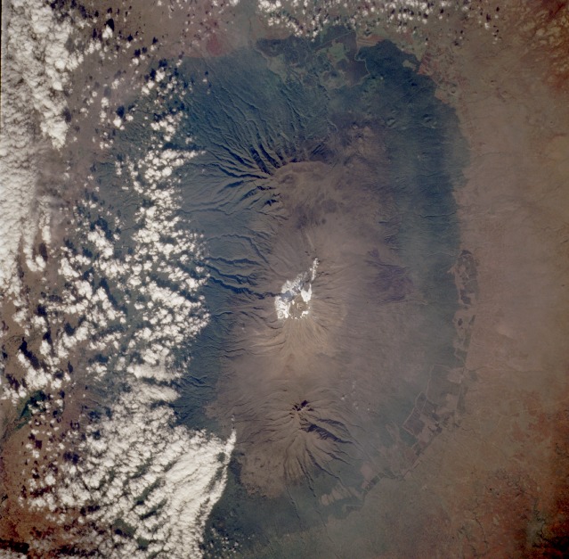 |
| STS066-117-063 Mount Kilimanjaro, Tanzania November 1994 Mount Kilimanjaro, the highest [19 340 feet (5895 meters)] and most famous mountain in Africa, is located in Tanzania just adjacent to the Kenya border. Three distinct volcanoes can be seen in this near-vertical photograph--Kibo (center volcano) with the highest peak and a permanent glacier and snow field at its summit; Shira (most westerly), the oldest that has been eroded into a plateau-like feature standing 12 395 feet (3778 meters) above sea level; and Mawenzi (most easterly) with a well-defined peak that reaches 17 564 feet (5354 meters) above sea level. The overlapping lava flows from these three volcanoes have almost obliterated their individual uniqueness into a single complex volcanic feature. The southern flanks of the mountain are more deeply eroded than northern slopes. Perhaps the cloud buildup indicates the increased severity of erosion is caused by more precipitation on the southern slopes than on the northern slopes. (Refer to photograph STS-41B-046-2957, which was taken 10 years earlier, to evaluate the change in the area of ice and snow and slight changes in land use patterns near the base of the mountains.) |
| Images: | All Available Images Low-Resolution 131k |
|
| Mission: | STS066 |
|
| Roll - Frame: | 117 - 63 |
|
| Geographical Name: | TANZANIA |
|
| Features: | KILIMANJARO, AGRICULTURE |
|
| Center Lat x Lon: | 3S x 37.5E |
|
| Film Exposure: | N | N=Normal exposure, U=Under exposed, O=Over exposed, F=out of Focus |
| Percentage of Cloud Cover-CLDP: | 20 |
|
| Camera:: | HB |
|
| Camera Tilt: | 10 | LO=Low Oblique, HO=High Oblique, NV=Near Vertical |
| Camera Focal Length: | 100 |
|
| Nadir to Photo Center Direction: | S | The direction from the nadir to the center point, N=North, S=South, E=East, W=West |
| Stereo?: | Y | Y=Yes there is an adjacent picture of the same area, N=No there isn't |
| Orbit Number: | 88 |
|
| Date: | 19941109 | YYYYMMDD |
| Time: | 053857 | GMT HHMMSS |
| Nadir Lat: | 2.6S |
Latitude of suborbital point of spacecraft |
| Nadir Lon: | 37.7E |
Longitude of suborbital point of spacecraft |
| Sun Azimuth: | 109 | Clockwise angle in degrees from north to the sun measured at the nadir point |
| Space Craft Altitude: | 159 | nautical miles |
| Sun Elevation: | 36 | Angle in degrees between the horizon and the sun, measured at the nadir point |
| Land Views: | MOUNTAIN, VOLCANO, CRATER, PLATEAU, FOREST |
|
| Water Views: | |
|
| Atmosphere Views: | |
|
| Man Made Views: | AGRICULTURE, DEFORESTATION |
|
| City Views: | |
|
Photo is not associated with any sequences | ||
| NASA Home Page |
JSC Home Page |
JSC Digital Image Collection |
Earth Science & Remote Sensing |
|
This service is provided by the International Space Station program and the JSC Earth Science & Remote Sensing Unit, ARES Division, Exploration Integration Science Directorate.

|