
Geographic Region: USA-ILLINOIS
Feature: MISSISSIPPI R, DAVENPORT
|
Geographic Region: USA-ILLINOIS Feature: MISSISSIPPI R, DAVENPORT |
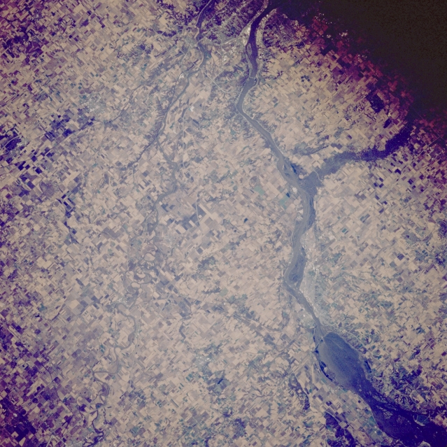 |
| STS066-103-049 Mississippi River and Clinton, Iowa, U.S.A. November 1994 The agricultural lands of northwestern Illinois and eastern Iowa are featured in this southwest-looking, low-oblique photograph. The Mississippi River is discernible from Lake Clinton and Clinton (right of center) to the quad cities to the south. The Wapsipinicon River enters the Mississippi River southwest of Clinton, a rail center in a rich corn- and livestock-producing area. |
| Images: | All Available Images Low-Resolution 391k |
|
| Mission: | STS066 |
|
| Roll - Frame: | 103 - 49 |
|
| Geographical Name: | USA-ILLINOIS |
|
| Features: | MISSISSIPPI R, DAVENPORT |
|
| Center Lat x Lon: | 41.5N x 90.5W |
|
| Film Exposure: | N | N=Normal exposure, U=Under exposed, O=Over exposed, F=out of Focus |
| Percentage of Cloud Cover-CLDP: | 0 |
|
| Camera:: | HB |
|
| Camera Tilt: | 19 | LO=Low Oblique, HO=High Oblique, NV=Near Vertical |
| Camera Focal Length: | 250 |
|
| Nadir to Photo Center Direction: | SW | The direction from the nadir to the center point, N=North, S=South, E=East, W=West |
| Stereo?: | N | Y=Yes there is an adjacent picture of the same area, N=No there isn't |
| Orbit Number: | 49 |
|
| Date: | 19941106 | YYYYMMDD |
| Time: | 173430 | GMT HHMMSS |
| Nadir Lat: | 42.1N |
Latitude of suborbital point of spacecraft |
| Nadir Lon: | 89.8W |
Longitude of suborbital point of spacecraft |
| Sun Azimuth: | 178 | Clockwise angle in degrees from north to the sun measured at the nadir point |
| Space Craft Altitude: | 162 | nautical miles |
| Sun Elevation: | 32 | Angle in degrees between the horizon and the sun, measured at the nadir point |
| Land Views: | |
|
| Water Views: | RIVER |
|
| Atmosphere Views: | |
|
| Man Made Views: | DAM, AGRICULTURE, URBAN AREA |
|
| City Views: | |
|
Photo is not associated with any sequences | ||
| NASA Home Page |
JSC Home Page |
JSC Digital Image Collection |
Earth Science & Remote Sensing |
|
This service is provided by the International Space Station program and the JSC Earth Science & Remote Sensing Unit, ARES Division, Exploration Integration Science Directorate.

|