
Geographic Region: GREECE
Feature: AMVRAKIKOS BAY, MTS.,IS.
|
Geographic Region: GREECE Feature: AMVRAKIKOS BAY, MTS.,IS. |
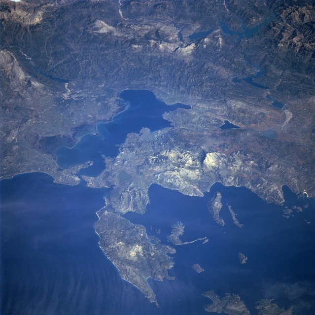 |
| STS066-101-039 Levkas Island, Ambracian Bay, Greece November, 1994 The Ambracian Bay, an inlet of the Ionian Sea (bottom left) can be seen in this northeast-looking view. The bay, sometimes referred to as a gulf, is 25 miles 40 km) long and from 4 to 10 miles (6 to 16 km) wide. On the shores of Ambracian Bay are the ruins of several cities important to ancient Greece. Levkas (Leucas) Island is visible in the lower left quadrant of the image. Levkas Island is a mountainous island that covers an area of 115 square miles (300 square km). Olive oil, wine, and tobacco are produced on the island. Covering almost a third of the top portion of the image is the western half of the Pindus Mountains. The Pindus, trending northwest to southeast are a continuation of the Dinaric Alps, but are made up of reduced limestone content compared to the range further to the north. Extending for 100 miles (160 km), the sparsely populated, rugged range is rich in timber. Lake Takhniti, a recreational lake, is discernible in the upper right portion of the image. Ithaki Island is visible near the bottom right of the image. |
| Images: | All Available Images Low-Resolution 335k |
|
| Mission: | STS066 |
|
| Roll - Frame: | 101 - 39 |
|
| Geographical Name: | GREECE |
|
| Features: | AMVRAKIKOS BAY, MTS.,IS. |
|
| Center Lat x Lon: | 38.5N x 21.0E |
|
| Film Exposure: | N | N=Normal exposure, U=Under exposed, O=Over exposed, F=out of Focus |
| Percentage of Cloud Cover-CLDP: | 5 |
|
| Camera:: | HB |
|
| Camera Tilt: | 39 | LO=Low Oblique, HO=High Oblique, NV=Near Vertical |
| Camera Focal Length: | 100 |
|
| Nadir to Photo Center Direction: | NE | The direction from the nadir to the center point, N=North, S=South, E=East, W=West |
| Stereo?: | Y | Y=Yes there is an adjacent picture of the same area, N=No there isn't |
| Orbit Number: | 44 |
|
| Date: | 19941106 | YYYYMMDD |
| Time: | 100020 | GMT HHMMSS |
| Nadir Lat: | 37.2N |
Latitude of suborbital point of spacecraft |
| Nadir Lon: | 19.2E |
Longitude of suborbital point of spacecraft |
| Sun Azimuth: | 172 | Clockwise angle in degrees from north to the sun measured at the nadir point |
| Space Craft Altitude: | 162 | nautical miles |
| Sun Elevation: | 37 | Angle in degrees between the horizon and the sun, measured at the nadir point |
| Land Views: | MOUNTAIN, COAST, ISLAND |
|
| Water Views: | BAY, LAKE, INLET |
|
| Atmosphere Views: | |
|
| Man Made Views: | |
|
| City Views: | |
|
Photo is not associated with any sequences | ||
| NASA Home Page |
JSC Home Page |
JSC Digital Image Collection |
Earth Science & Remote Sensing |
|
This service is provided by the International Space Station program and the JSC Earth Science & Remote Sensing Unit, ARES Division, Exploration Integration Science Directorate.

|