Geographic Region: USA-HAWAII
Feature: MOLOKAI, LANAI ISLANDS
|
Geographic Region: USA-HAWAII Feature: MOLOKAI, LANAI ISLANDS |
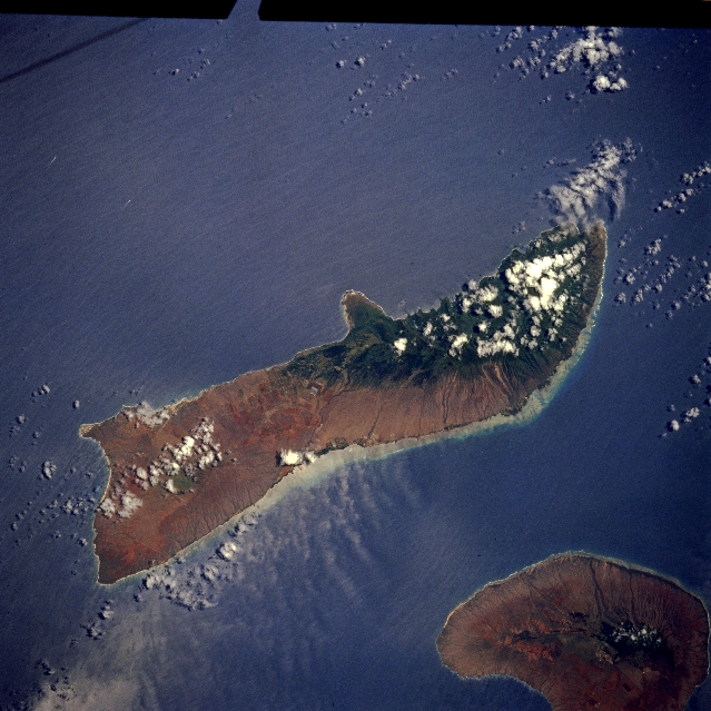 |
| STS065-096-009 Molokai, Hawaii, U.S.A. July 1994 The higher elevations along the northeastern third of Molokai, some at 4970 feet (1515 meters), have a dramatic impact on the amount of precipitation that falls from one island to another and on different parts of the same island. The rain shadow effect--drier conditions in the west (signified by lighter colors)--is the result of the northeast trade winds hitting the higher elevations in the east and dropping most of the moisture along the northeastern end of the island (darker colors indicate vegetation). The remote peninsula that juts northward in the middle of the north coast is the site of Kalaupapa National Historical Park. A leper colony was established in 1866 on this remote peninsula. A well-established coral reef system is visible along the south and southeastern shorelines of Molokai, south of which lies Lanai. |
| Images: | All Available Images Low-Resolution 334k |
|
| Mission: | STS065 |
|
| Roll - Frame: | 96 - 9 |
|
| Geographical Name: | USA-HAWAII |
|
| Features: | MOLOKAI, LANAI ISLANDS |
|
| Center Lat x Lon: | 21.0N x 157W |
|
| Film Exposure: | N | N=Normal exposure, U=Under exposed, O=Over exposed, F=out of Focus |
| Percentage of Cloud Cover-CLDP: | 10 |
|
| Camera:: | HB |
|
| Camera Tilt: | 18 | LO=Low Oblique, HO=High Oblique, NV=Near Vertical |
| Camera Focal Length: | 250 |
|
| Nadir to Photo Center Direction: | E | The direction from the nadir to the center point, N=North, S=South, E=East, W=West |
| Stereo?: | Y | Y=Yes there is an adjacent picture of the same area, N=No there isn't |
| Orbit Number: | 84 |
|
| Date: | 19940713 | YYYYMMDD |
| Time: | 215715 | GMT HHMMSS |
| Nadir Lat: | 21.3N |
Latitude of suborbital point of spacecraft |
| Nadir Lon: | 157.8W |
Longitude of suborbital point of spacecraft |
| Sun Azimuth: | 85 | Clockwise angle in degrees from north to the sun measured at the nadir point |
| Space Craft Altitude: | 160 | nautical miles |
| Sun Elevation: | 81 | Angle in degrees between the horizon and the sun, measured at the nadir point |
| Land Views: | ISLAND |
|
| Water Views: | |
|
| Atmosphere Views: | |
|
| Man Made Views: | |
|
| City Views: | |
|
Photo is not associated with any sequences | ||
| NASA Home Page |
JSC Home Page |
JSC Digital Image Collection |
Earth Science & Remote Sensing |
|
This service is provided by the International Space Station program and the JSC Earth Science & Remote Sensing Unit, ARES Division, Exploration Integration Science Directorate.

|