Geographic Region: USA-HAWAII
Feature: OAHU,AGR.,HONOLULU
|
Geographic Region: USA-HAWAII Feature: OAHU,AGR.,HONOLULU |
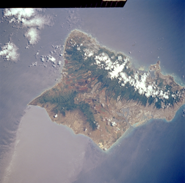 |
| STS065-96-7 Oahu, Hawaii, U.S.A. July 1994 The influence of the northeast trade winds on the island of Oahu is apparent by the formation of clouds on the windward slopes of the Koolau Range in northeastern Oahu and by a highly reflective island wake (created by the current flow of water around the island) off the southwest coast of the island. A broad, cultivated, northwest-southeast-aligned valley connects the Koolau Range with the higher paralleling Waianae Range along the southwestern side of Oahu. Kaala Mountain [4046 feet (1233 meters)] in the Waianae Range is the highest elevation on Oahu. Pearl Harbor, Honolulu, Honolulu International Airport, and Diamond Head Crater are discernible along the southern coast of the island. STS-65 Earth observation taken aboard Columbia, Orbiter Vehicle (OV) 102, shows Oahu, Hawaii. The island wake emerging to the lower left side of Oahu is caused by wind currents blowing from the northeast being obstructed by the northwest-southeast trending, cloud covered, Koolau mountain range. The lighter colored water indicates a more smooth surface with a slower water current that the darker, rougher, faster moving water current. Pearl Harbor is visible to the south of the Koolau Range. To the right, or east, of Pearl Harbor is the city of Honolulu. The circular, brown feature to the east of Honolulu is the dormant volcano Diamond Head. |
| Images: | All Available Images Low-Resolution 284k |
|
| Mission: | STS065 |
|
| Roll - Frame: | 96 - 7 |
|
| Geographical Name: | USA-HAWAII |
|
| Features: | OAHU,AGR.,HONOLULU |
|
| Center Lat x Lon: | 21.5N x 158W |
|
| Film Exposure: | N | N=Normal exposure, U=Under exposed, O=Over exposed, F=out of Focus |
| Percentage of Cloud Cover-CLDP: | 10 |
|
| Camera:: | HB |
|
| Camera Tilt: | 25 | LO=Low Oblique, HO=High Oblique, NV=Near Vertical |
| Camera Focal Length: | 250 |
|
| Nadir to Photo Center Direction: | E | The direction from the nadir to the center point, N=North, S=South, E=East, W=West |
| Stereo?: | Y | Y=Yes there is an adjacent picture of the same area, N=No there isn't |
| Orbit Number: | 84 |
|
| Date: | 19940713 | YYYYMMDD |
| Time: | 215654 | GMT HHMMSS |
| Nadir Lat: | 21.8N |
Latitude of suborbital point of spacecraft |
| Nadir Lon: | 159.2W |
Longitude of suborbital point of spacecraft |
| Sun Azimuth: | 87 | Clockwise angle in degrees from north to the sun measured at the nadir point |
| Space Craft Altitude: | 160 | nautical miles |
| Sun Elevation: | 79 | Angle in degrees between the horizon and the sun, measured at the nadir point |
| Land Views: | ISLAND, VALLEY, MOUNTAIN |
|
| Water Views: | ISLAND WAKE |
|
| Atmosphere Views: | |
|
| Man Made Views: | AGRICULTURE, URBAN AREA, AIRPORT |
|
| City Views: | |
|
Photo is not associated with any sequences | ||
| NASA Home Page |
JSC Home Page |
JSC Digital Image Collection |
Earth Science & Remote Sensing |
|
This service is provided by the International Space Station program and the JSC Earth Science & Remote Sensing Unit, ARES Division, Exploration Integration Science Directorate.

|