Geographic Region: INDONESIA
Feature: FLORES I., VOL.
|
Geographic Region: INDONESIA Feature: FLORES I., VOL. |
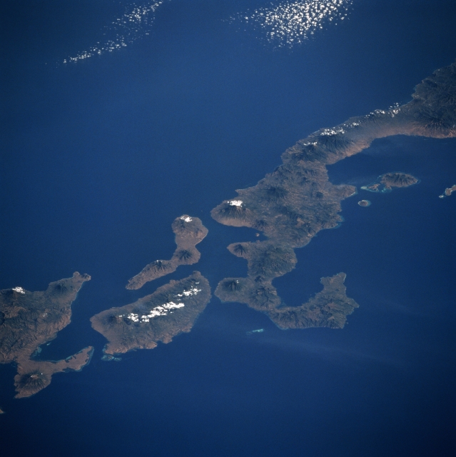 |
| STS065-094-043 Adonara, Flores, Lomblem Islands, Indonesia July 1994 Numerous volcanic peaks can be seen in this spectacular southwest-looking view of the Indonesian Islands of Flores, Adonara, Solor, and Lomblem. Extending from near the upper right to near the center of the image is the eastern half of Flores Island. Over 233 miles (375 km) long, Flores has many landscapes, including lush paddy fields, arid plains, rugged hills, and dense jungles. The coastline has few inlets and there are no large rivers on the island. There are however, numerous volcanoes, fourteen of which are active. Flores Island is considered to be one of the most geological unstable places on earth. Copra, rice, maize, and coffee are grown on the fertile volcanic soils and cattle are also raised. The small, elongated island east (left) of Flores is Solor Island. This small mountainous island, with at least 5 volcanoes, is 25 miles (40 km) long and 4 miles (6 km) wide. Raising copra and fishing are the main industries of the island. The larger island to the east (left) of Flores is Adonara Island with its major active volcano, Ile Boleng. The volcano is visible just to the left of a line of clouds on the southeastern part of Adonara. Adonara covers an area of 224 sq. miles (580 sq. km) and is 23 miles (37 km) long and 11 miles (18 km) wide. At the bottem left of the image, the western third of the irregular shaped and volcanic island of Lomblem is discernible. |
| Images: | All Available Images Low-Resolution 249k |
|
| Mission: | STS065 |
|
| Roll - Frame: | 94 - 43 |
|
| Geographical Name: | INDONESIA |
|
| Features: | FLORES I., VOL. |
|
| Center Lat x Lon: | 8.5S x 122.5E |
|
| Film Exposure: | N | N=Normal exposure, U=Under exposed, O=Over exposed, F=out of Focus |
| Percentage of Cloud Cover-CLDP: | 0 |
|
| Camera:: | HB |
|
| Camera Tilt: | LO | LO=Low Oblique, HO=High Oblique, NV=Near Vertical |
| Camera Focal Length: | 100 |
|
| Nadir to Photo Center Direction: | SW | The direction from the nadir to the center point, N=North, S=South, E=East, W=West |
| Stereo?: | Y | Y=Yes there is an adjacent picture of the same area, N=No there isn't |
| Orbit Number: | 74 |
|
| Date: | 19940713 | YYYYMMDD |
| Time: | 070916 | GMT HHMMSS |
| Nadir Lat: | 5.5S |
Latitude of suborbital point of spacecraft |
| Nadir Lon: | 125.2E |
Longitude of suborbital point of spacecraft |
| Sun Azimuth: | 301 | Clockwise angle in degrees from north to the sun measured at the nadir point |
| Space Craft Altitude: | 163 | nautical miles |
| Sun Elevation: | 33 | Angle in degrees between the horizon and the sun, measured at the nadir point |
| Land Views: | ISLAND, VOLCANO, COAST |
|
| Water Views: | STRAIT, BAY |
|
| Atmosphere Views: | |
|
| Man Made Views: | |
|
| City Views: | |
|
Photo is not associated with any sequences | ||
| NASA Home Page |
JSC Home Page |
JSC Digital Image Collection |
Earth Science & Remote Sensing |
|
This service is provided by the International Space Station program and the JSC Earth Science & Remote Sensing Unit, ARES Division, Exploration Integration Science Directorate.

|