Geographic Region: INDONESIA-WNG
Feature: COAST, BIAN RIVER, ROAD
|
Geographic Region: INDONESIA-WNG Feature: COAST, BIAN RIVER, ROAD |
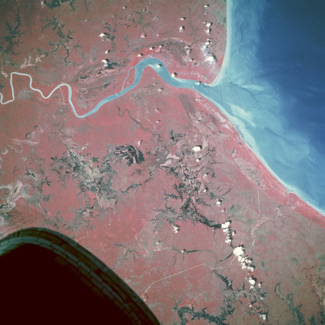 |
| STS065-112-043 Southern Coast, Irian Jaya, Indonesia July 1994 The southeastern coast of Irian Jaya, Indonesia, remains a sparsely inhabited landscape consisting of dense, impenetrable forests; extensive wetlands; and swamps. This near-vertical photograph of the coastline and the mouth of the Bian River indicates a wetland environment only slightly impacted by humans. The reds, representing tropical vegetation, and the blacks, representing swamps and open water features, graphically capture the pristine conditions of this area. The major indication of human impact on this environment is the narrow, highly reflective, generally north-south line near the western edge of the photograph that could be a new road into the interior or a jungle pipeline right-of-way. A few features adjacent to the coastline appear to be roads or clearings where small settlements exist. |
| Images: | All Available Images Low-Resolution 108k |
|
| Mission: | STS065 |
|
| Roll - Frame: | 112 - 43 |
|
| Geographical Name: | INDONESIA-WNG |
|
| Features: | COAST, BIAN RIVER, ROAD |
|
| Center Lat x Lon: | 8S x 139.5E |
|
| Film Exposure: | N | N=Normal exposure, U=Under exposed, O=Over exposed, F=out of Focus |
| Percentage of Cloud Cover-CLDP: | 10 |
|
| Camera:: | HB |
|
| Camera Tilt: | 8 | LO=Low Oblique, HO=High Oblique, NV=Near Vertical |
| Camera Focal Length: | 250 |
|
| Nadir to Photo Center Direction: | S | The direction from the nadir to the center point, N=North, S=South, E=East, W=West |
| Stereo?: | Y | Y=Yes there is an adjacent picture of the same area, N=No there isn't |
| Orbit Number: | 167 |
|
| Date: | 19940719 | YYYYMMDD |
| Time: | 031025 | GMT HHMMSS |
| Nadir Lat: | 7.6S |
Latitude of suborbital point of spacecraft |
| Nadir Lon: | 139.5E |
Longitude of suborbital point of spacecraft |
| Sun Azimuth: | 349 | Clockwise angle in degrees from north to the sun measured at the nadir point |
| Space Craft Altitude: | 162 | nautical miles |
| Sun Elevation: | 61 | Angle in degrees between the horizon and the sun, measured at the nadir point |
| Land Views: | COAST, PLAIN |
|
| Water Views: | RIVER, SWAMP |
|
| Atmosphere Views: | |
|
| Man Made Views: | |
|
| City Views: | IRIAN JAYA |
|
Photo is not associated with any sequences | ||
| NASA Home Page |
JSC Home Page |
JSC Digital Image Collection |
Earth Science & Remote Sensing |
|
This service is provided by the International Space Station program and the JSC Earth Science & Remote Sensing Unit, ARES Division, Exploration Integration Science Directorate.

|