Geographic Region: NEW ZEALAND-SI
Feature: BANKS PENINSULA
|
Geographic Region: NEW ZEALAND-SI Feature: BANKS PENINSULA |
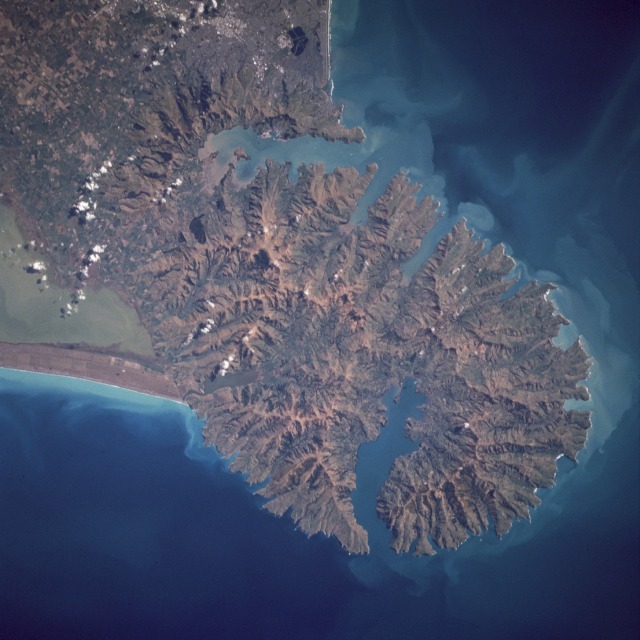 |
| STS064-098-075 Bank's Peninsula, South Island, New Zealand September 1994 Bank's Peninsula, the only recognizable volcanic feature in South Island, is an ancient formation that has been deeply eroded but still possesses the classic circular shape and radial drainage pattern that typify many volcanoes. The peninsula is actually formed by two overlapping volcanic centers--the Lyttelton Volcano northwest and the Akaroa Volcano southeast of the formation. The two large harbors have the same names as the ancient volcanoes. Bank's Peninsula is joined to the Canterbury Plains to the west by the coalescing alluvial fans formed by the rivers draining the Southern Alps. North and west of the peninsula, sediment deposited by the rivers has been redeposited by the long shore drift to form the New Brighton (north) and Kaitorete (west) spits. Other features are visible in this photograph--Pegasus Bay to the north, Canterbury Bight to the south, the eastern end of Lake Ellesmere to the southwest, and part of the city of Christchurch to the northwest. |
| Images: | All Available Images Low-Resolution 104k |
|
| Mission: | STS064 |
|
| Roll - Frame: | 98 - 75 |
|
| Geographical Name: | NEW ZEALAND-SI |
|
| Features: | BANKS PENINSULA |
|
| Center Lat x Lon: | 44S x 173.0E |
|
| Film Exposure: | N | N=Normal exposure, U=Under exposed, O=Over exposed, F=out of Focus |
| Percentage of Cloud Cover-CLDP: | 0 |
|
| Camera:: | HB |
|
| Camera Tilt: | LO | LO=Low Oblique, HO=High Oblique, NV=Near Vertical |
| Camera Focal Length: | 250 |
|
| Nadir to Photo Center Direction: | The direction from the nadir to the center point, N=North, S=South, E=East, W=West |
|
| Stereo?: | N | Y=Yes there is an adjacent picture of the same area, N=No there isn't |
| Orbit Number: | |
|
| Date: | 199409__ | YYYYMMDD |
| Time: | GMT HHMMSS |
|
| Nadir Lat: | N |
Latitude of suborbital point of spacecraft |
| Nadir Lon: | E |
Longitude of suborbital point of spacecraft |
| Sun Azimuth: | Clockwise angle in degrees from north to the sun measured at the nadir point |
|
| Space Craft Altitude: | nautical miles |
|
| Sun Elevation: | Angle in degrees between the horizon and the sun, measured at the nadir point |
|
| Land Views: | VOLCANO, COAST, PENINSULA |
|
| Water Views: | BAY, ESTUARY, LAGOON |
|
| Atmosphere Views: | |
|
| Man Made Views: | URBAN AREA |
|
| City Views: | |
|
Photo is not associated with any sequences | ||
| NASA Home Page |
JSC Home Page |
JSC Digital Image Collection |
Earth Science & Remote Sensing |
|
This service is provided by the International Space Station program and the JSC Earth Science & Remote Sensing Unit, ARES Division, Exploration Integration Science Directorate.

|