
Geographic Region: AUSTRALIA-Q
Feature: BRISBANE, MORETON B, MTS
|
Geographic Region: AUSTRALIA-Q Feature: BRISBANE, MORETON B, MTS |
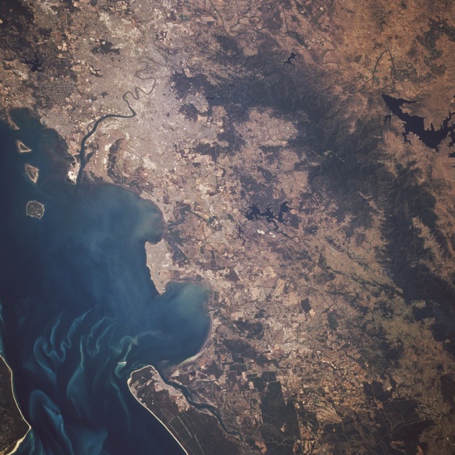 |
| STS064-092-045 Brisbane and Moreton Bay, Queensland, Australia September 1994 Brisbane, founded in 1824 as one of Australia's penal colonies and now Australia's third largest urban center, is seen in the southeast corner of this low-oblique, south-looking photograph. Brisbane, the capital of Queensland, occupies the rolling terrain on either side of the Brisbane River, spreading eastward to Moreton Bay and westward into the foothills of the Great Dividing Range. Brisbane's major commercial industries include shipyards, oil and sugar refineries, food processing plants, textile mills, automobile plants, agriculture products, machinery manufacturing, and railroad workshops. The large runway of the Brisbane International Airport is west of the Brisbane River near the river's entrance into Moreton Bay. The bay, which serves as the entrance to the Port of Brisbane, is 65 miles (105 kilometers) long and 20 miles (32 kilometers) wide. |
| Images: | All Available Images Low-Resolution 143k |
|
| Mission: | STS064 |
|
| Roll - Frame: | 92 - 45 |
|
| Geographical Name: | AUSTRALIA-Q |
|
| Features: | BRISBANE, MORETON B, MTS |
|
| Center Lat x Lon: | 27.5S x 153.0E |
|
| Film Exposure: | N | N=Normal exposure, U=Under exposed, O=Over exposed, F=out of Focus |
| Percentage of Cloud Cover-CLDP: | 0 |
|
| Camera:: | HB |
|
| Camera Tilt: | 36 | LO=Low Oblique, HO=High Oblique, NV=Near Vertical |
| Camera Focal Length: | 250 |
|
| Nadir to Photo Center Direction: | SW | The direction from the nadir to the center point, N=North, S=South, E=East, W=West |
| Stereo?: | Y | Y=Yes there is an adjacent picture of the same area, N=No there isn't |
| Orbit Number: | 83 |
|
| Date: | 19940915 | YYYYMMDD |
| Time: | 021357 | GMT HHMMSS |
| Nadir Lat: | 26.4S |
Latitude of suborbital point of spacecraft |
| Nadir Lon: | 154.3E |
Longitude of suborbital point of spacecraft |
| Sun Azimuth: | 342 | Clockwise angle in degrees from north to the sun measured at the nadir point |
| Space Craft Altitude: | 140 | nautical miles |
| Sun Elevation: | 59 | Angle in degrees between the horizon and the sun, measured at the nadir point |
| Land Views: | COAST, FOREST, MOUNTAIN |
|
| Water Views: | BAY, RIVER |
|
| Atmosphere Views: | |
|
| Man Made Views: | URBAN AREA, AIRPORT |
|
| City Views: | BRISBANE |
|
Photo is not associated with any sequences | ||
| NASA Home Page |
JSC Home Page |
JSC Digital Image Collection |
Earth Science & Remote Sensing |
|
This service is provided by the International Space Station program and the JSC Earth Science & Remote Sensing Unit, ARES Division, Exploration Integration Science Directorate.

|