
Geographic Region: AUSTRALIA-Q
Feature: SURFERS PARADISE, MTS,IS
|
Geographic Region: AUSTRALIA-Q Feature: SURFERS PARADISE, MTS,IS |
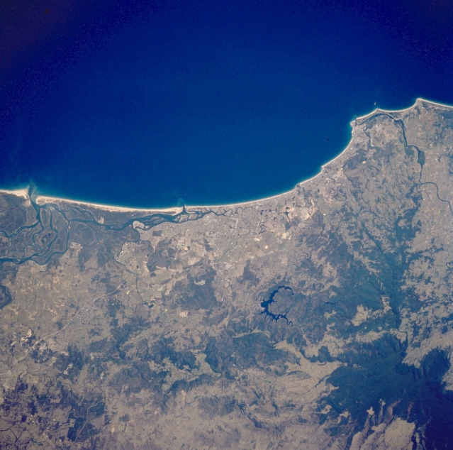 |
| STS064-92-043 Surfers Paradise Area, Queensland, Australia September 1994 The coastal city of Surfers Paradise, located approximately 35 miles (56 kilometers) southeast of Brisbane, is located near the center of this image. Several cities aligned along this coast merge together with Surfers Paradise to form the Gold Coast of Queensland. The very dark area in the lower right quadrant of the image is part of the thickly vegetated subtropical rainforest that straddles the Queensland and New South Wales border. The U-shaped (dark feature) is a reservoir that has been constructed on the Coomeral River on the northern flank of Tweed (Wollumbin) Volcano. Careful examination of this image shows part of the radial drainage pattern on the northern side of the volcano. This volcano last erupted 20 million years ago and is also called Mount Warning. |
| Images: | All Available Images Low-Resolution 334k |
|
| Mission: | STS064 |
|
| Roll - Frame: | 92 - 43 |
|
| Geographical Name: | AUSTRALIA-Q |
|
| Features: | SURFERS PARADISE, MTS,IS |
|
| Center Lat x Lon: | 28S x 153.5E |
|
| Film Exposure: | N | N=Normal exposure, U=Under exposed, O=Over exposed, F=out of Focus |
| Percentage of Cloud Cover-CLDP: | 0 |
|
| Camera:: | HB |
|
| Camera Tilt: | 25 | LO=Low Oblique, HO=High Oblique, NV=Near Vertical |
| Camera Focal Length: | 250 |
|
| Nadir to Photo Center Direction: | S | The direction from the nadir to the center point, N=North, S=South, E=East, W=West |
| Stereo?: | Y | Y=Yes there is an adjacent picture of the same area, N=No there isn't |
| Orbit Number: | 83 |
|
| Date: | 19940915 | YYYYMMDD |
| Time: | 021347 | GMT HHMMSS |
| Nadir Lat: | 27S |
Latitude of suborbital point of spacecraft |
| Nadir Lon: | 153.9E |
Longitude of suborbital point of spacecraft |
| Sun Azimuth: | 343 | Clockwise angle in degrees from north to the sun measured at the nadir point |
| Space Craft Altitude: | 140 | nautical miles |
| Sun Elevation: | 59 | Angle in degrees between the horizon and the sun, measured at the nadir point |
| Land Views: | FOREST, VOLCANO, ISLAND |
|
| Water Views: | RIVER, OCEAN |
|
| Atmosphere Views: | |
|
| Man Made Views: | |
|
| City Views: | |
|
Photo is not associated with any sequences | ||
| NASA Home Page |
JSC Home Page |
JSC Digital Image Collection |
Earth Science & Remote Sensing |
|
This service is provided by the International Space Station program and the JSC Earth Science & Remote Sensing Unit, ARES Division, Exploration Integration Science Directorate.

|