
Geographic Region: BOLIVIA
Feature: LAKE POOPO, DRY
|
Geographic Region: BOLIVIA Feature: LAKE POOPO, DRY |
 |
| STS064-091-022 Lake Poopó, Bolivia September 1994 An almost dried-up Lake Poopo (also called Lake Aullagas) is visible in this low-oblique, west-looking photograph. Lake waters have been receding since 1990 (refer to STS-048-072-049, September 1991), and the inflow of the Desaguadero River at the lake's north end (brown) has slowed to a trickle. At the south end of the lake is a small river that drains Lake Poopo and follows a westward course until it finally drains into Salar de Coipasa (not visible in the photograph). Without years of near-normal or above-normal precipitation in the region, the lake will continue to dry because of evaporation resulting from intense sunshine and strong winds. A small light blue lake is visible east of Lake Poopo near the town of Challapata (grayish smudge at the base of the mountains south of the small lake). With the carrying capacity of Lake Poopo becoming inadequate, migratory wading birds from North America will need to find other area lakes for their wintering grounds. |
| Images: | All Available Images Low-Resolution 94k |
|
| Mission: | STS064 |
|
| Roll - Frame: | 91 - 22 |
|
| Geographical Name: | BOLIVIA |
|
| Features: | LAKE POOPO, DRY |
|
| Center Lat x Lon: | 19S x 67W |
|
| Film Exposure: | N | N=Normal exposure, U=Under exposed, O=Over exposed, F=out of Focus |
| Percentage of Cloud Cover-CLDP: | 0 |
|
| Camera:: | HB |
|
| Camera Tilt: | 49 | LO=Low Oblique, HO=High Oblique, NV=Near Vertical |
| Camera Focal Length: | 250 |
|
| Nadir to Photo Center Direction: | W | The direction from the nadir to the center point, N=North, S=South, E=East, W=West |
| Stereo?: | Y | Y=Yes there is an adjacent picture of the same area, N=No there isn't |
| Orbit Number: | 77 |
|
| Date: | 19940914 | YYYYMMDD |
| Time: | 171803 | GMT HHMMSS |
| Nadir Lat: | 20.2S |
Latitude of suborbital point of spacecraft |
| Nadir Lon: | 64.6W |
Longitude of suborbital point of spacecraft |
| Sun Azimuth: | 324 | Clockwise angle in degrees from north to the sun measured at the nadir point |
| Space Craft Altitude: | 140 | nautical miles |
| Sun Elevation: | 62 | Angle in degrees between the horizon and the sun, measured at the nadir point |
| Land Views: | PLATEAU, MOUNTAIN |
|
| Water Views: | LAKE |
|
| Atmosphere Views: | |
|
| Man Made Views: | |
|
| City Views: | |
|
Associated Photos in Sequence:  Photo #: STS057-99-65 Photo #: STS057-99-65Description: PERU/BOLIVIA-1993; L. TITICACA, L. POOPO REGION-SYNOPTIC VIEW Sequence ID: 6A  Photo #: SL3-115-1911 Photo #: SL3-115-1911Description: BOLIVIA, LAKE POOPO-1973; LAKE LEVEL Sequence ID: 6B  Photo #: STS51J-144-23 Photo #: STS51J-144-23Description: BOLIVIA, LAKE POOPO-1985; LAKE LEVEL Sequence ID: 6C 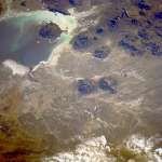 Photo #: STS026-40-64 Photo #: STS026-40-64Description: BOLIVIA, LAKE POOPO, LAKE COIPASA-1988; LAKE POOPO LAKE LEVEL Sequence ID: 6D  Photo #: STS032-88-69 Photo #: STS032-88-69Description: BOLIVIA, LAKE POOPO-1990; LAKE LEVEL Sequence ID: 6E  Photo #: STS048-72-49 Photo #: STS048-72-49Description: BOLIVIA, LAKE POOPO-1991; LAKE LEVEL CHANGES Sequence ID: 6F  Photo #: STS064-91-22 ** Currently displayed photo ** Photo #: STS064-91-22 ** Currently displayed photo ** Description: BOLIVIA, LAKE POOPO-1994; DECREASING LAKE LEVEL Sequence ID: 6G  Photo #: STS073-735-47 Photo #: STS073-735-47Description: BOLIVIA, LAKE POOPO-1995; LAKE IS DRY Sequence ID: 6H | ||
| NASA Home Page |
JSC Home Page |
JSC Digital Image Collection |
Earth Science & Remote Sensing |
|
This service is provided by the International Space Station program and the JSC Earth Science & Remote Sensing Unit, ARES Division, Exploration Integration Science Directorate.

|