Geographic Region: LESSER ANTILLES
Feature: ANTIGUA I., SUNGLINT
|
Geographic Region: LESSER ANTILLES Feature: ANTIGUA I., SUNGLINT |
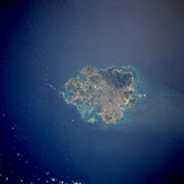 |
| STS064-76-BB Antigua, Leeward Islands September 1994 Antigua, a low-lying, semiarid, limestone island of the Lesser Antilles, is part of a two-island independent state, Antigua and Barbuda. Antigua has severely eroded volcanic remnants along its forested southwestern quadrant, which has a maximum elevation of only 1319 feet (402 meters) above sea level. Although Antigua receives approximately 40 inches (100 centimeters) of precipitation annually, wide fluctuations in rainfall amounts occasionally create serious water shortages, especially for the agricultural industry. Some of the larger hotels transport water by barge from nearby islands when water supplies become critically low. At one time Antigua's economy was based largely on the sugarcane industry, but light manufacturing and tourism are now the leading contributors to the island's economy. St. John's, the country's capital, is located along the northwest coast, adjacent to one of the island's many natural harbors. More than half of the country's population of almost 80 000 live in the St. John's area. The island is approximately 16 miles (25 kilometers) east-west and 12 miles (19 kilometers) north-south. |
| Images: | All Available Images Low-Resolution 74k |
|
| Mission: | STS064 |
|
| Roll - Frame: | 76 - BB |
|
| Geographical Name: | LESSER ANTILLES |
|
| Features: | ANTIGUA I., SUNGLINT |
|
| Center Lat x Lon: | 17.0N x 62W |
|
| Film Exposure: | N | N=Normal exposure, U=Under exposed, O=Over exposed, F=out of Focus |
| Percentage of Cloud Cover-CLDP: | 5 |
|
| Camera:: | HB |
|
| Camera Tilt: | NV | LO=Low Oblique, HO=High Oblique, NV=Near Vertical |
| Camera Focal Length: | 250 |
|
| Nadir to Photo Center Direction: | The direction from the nadir to the center point, N=North, S=South, E=East, W=West |
|
| Stereo?: | Y | Y=Yes there is an adjacent picture of the same area, N=No there isn't |
| Orbit Number: | |
|
| Date: | 199409__ | YYYYMMDD |
| Time: | GMT HHMMSS |
|
| Nadir Lat: | N |
Latitude of suborbital point of spacecraft |
| Nadir Lon: | E |
Longitude of suborbital point of spacecraft |
| Sun Azimuth: | Clockwise angle in degrees from north to the sun measured at the nadir point |
|
| Space Craft Altitude: | nautical miles |
|
| Sun Elevation: | Angle in degrees between the horizon and the sun, measured at the nadir point |
|
| Land Views: | ISLAND, COAST, MOUNTAIN |
|
| Water Views: | OCEAN, BAY, REEF |
|
| Atmosphere Views: | |
|
| Man Made Views: | URBAN AREA, AIRPORT |
|
| City Views: | |
|
Photo is not associated with any sequences | ||
| NASA Home Page |
JSC Home Page |
JSC Digital Image Collection |
Earth Science & Remote Sensing |
|
This service is provided by the International Space Station program and the JSC Earth Science & Remote Sensing Unit, ARES Division, Exploration Integration Science Directorate.

|