
Geographic Region: AUSTRALIA-V
Feature: AGRICULTURE, BURN SCARS
|
Geographic Region: AUSTRALIA-V Feature: AGRICULTURE, BURN SCARS |
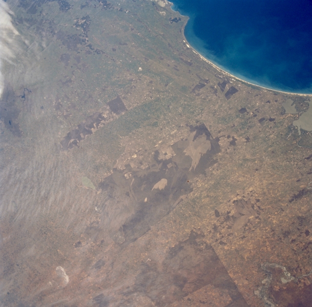 |
| STS064-72-072 Burn Scar, South Australia, Australia September 1994 The curving shoreline of the Younghusband Peninsula in southeast South Australia is shown here in this southeast-looking small-scale view. The coastline extends from estuarine Lakes Albert and Alexandrina (middle right) to beyond Cape Jaffa (upper middle). The lagoon and dunes inside the Younghusband Peninsula, the Coorong, provide a natural habitat for wetland birds and wilderness areas with an array of coastal sand dunes. The larger dark areas show where more densely vegetated terrain is located on the gently rolling, sandy hills. The lighter-colored unique pattern within the darker area (slightly right of center) shows an extensive burn scar, probably caused by a random lighting strike and resultant range fire. Some clouds can be seen along the left upper margin of the picture. The distinctive pattern in the bottom right corner of the picture is part of the Murray River and its floodplain. The straight, linear boundaries that are visible throughout the region are created by the darker, undeveloped landscape (mainly very sandy soils) versus the lighter-colored agricultural lands. |
| Images: | All Available Images Low-Resolution 298k |
|
| Mission: | STS064 |
|
| Roll - Frame: | 72 - 72 |
|
| Geographical Name: | AUSTRALIA-V |
|
| Features: | AGRICULTURE, BURN SCARS |
|
| Center Lat x Lon: | 35.5S x 141.5E |
|
| Film Exposure: | N | N=Normal exposure, U=Under exposed, O=Over exposed, F=out of Focus |
| Percentage of Cloud Cover-CLDP: | 5 |
|
| Camera:: | HB |
|
| Camera Tilt: | 20 | LO=Low Oblique, HO=High Oblique, NV=Near Vertical |
| Camera Focal Length: | 100 |
|
| Nadir to Photo Center Direction: | E | The direction from the nadir to the center point, N=North, S=South, E=East, W=West |
| Stereo?: | Y | Y=Yes there is an adjacent picture of the same area, N=No there isn't |
| Orbit Number: | 20 |
|
| Date: | 19940911 | YYYYMMDD |
| Time: | 040148 | GMT HHMMSS |
| Nadir Lat: | 35.8S |
Latitude of suborbital point of spacecraft |
| Nadir Lon: | 140.7E |
Longitude of suborbital point of spacecraft |
| Sun Azimuth: | 328 | Clockwise angle in degrees from north to the sun measured at the nadir point |
| Space Craft Altitude: | 140 | nautical miles |
| Sun Elevation: | 45 | Angle in degrees between the horizon and the sun, measured at the nadir point |
| Land Views: | HILL, COAST |
|
| Water Views: | LAKE, RESERVOIR |
|
| Atmosphere Views: | |
|
| Man Made Views: | |
|
| City Views: | |
|
Photo is not associated with any sequences | ||
| NASA Home Page |
JSC Home Page |
JSC Digital Image Collection |
Earth Science & Remote Sensing |
|
This service is provided by the International Space Station program and the JSC Earth Science & Remote Sensing Unit, ARES Division, Exploration Integration Science Directorate.

|