
Geographic Region: USA-LOUISIANA
Feature: BATON ROUGE, MISS. RIVER
|
Geographic Region: USA-LOUISIANA Feature: BATON ROUGE, MISS. RIVER |
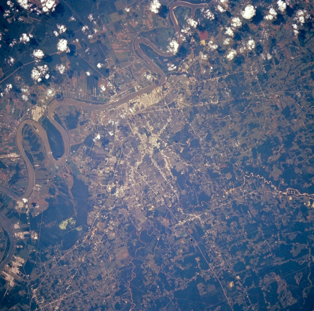 |
| STS064-216-086 Baton Rouge, Louisiana, U.S.A. September 1994 Baton Rouge, the capital of Louisiana, is situated on the eastern bank of the Mississippi River (near center of photograph). Discernible are many streets and highways throughout the metropolitan area and Interstate Highway 10, which connects Baton Rouge and Slidell. The highly reflective surfaces along the Mississippi River are petroleum processing facilities. Narrow "long lots" radiating from the Mississippi River illustrate French influence regarding the ownership of riverfront property. The smaller Amite River is visible east of Baton Rouge. Darker, uniform areas are dense stands of vegetation, primarily forests. |
| Images: | All Available Images Low-Resolution 399k |
|
| Mission: | STS064 |
|
| Roll - Frame: | 216 - 86 |
|
| Geographical Name: | USA-LOUISIANA |
|
| Features: | BATON ROUGE, MISS. RIVER |
|
| Center Lat x Lon: | 30.5N x 91W |
|
| Film Exposure: | N | N=Normal exposure, U=Under exposed, O=Over exposed, F=out of Focus |
| Percentage of Cloud Cover-CLDP: | 10 |
|
| Camera:: | HB |
|
| Camera Tilt: | 8 | LO=Low Oblique, HO=High Oblique, NV=Near Vertical |
| Camera Focal Length: | 250 |
|
| Nadir to Photo Center Direction: | W | The direction from the nadir to the center point, N=North, S=South, E=East, W=West |
| Stereo?: | Y | Y=Yes there is an adjacent picture of the same area, N=No there isn't |
| Orbit Number: | 144 |
|
| Date: | 19940918 | YYYYMMDD |
| Time: | 195249 | GMT HHMMSS |
| Nadir Lat: | 30.6N |
Latitude of suborbital point of spacecraft |
| Nadir Lon: | 90.7W |
Longitude of suborbital point of spacecraft |
| Sun Azimuth: | 229 | Clockwise angle in degrees from north to the sun measured at the nadir point |
| Space Craft Altitude: | 129 | nautical miles |
| Sun Elevation: | 50 | Angle in degrees between the horizon and the sun, measured at the nadir point |
| Land Views: | PLAIN |
|
| Water Views: | RIVER |
|
| Atmosphere Views: | |
|
| Man Made Views: | URBAN AREA, HIGHWAY, AGRICULTURE |
|
| City Views: | BATON ROUGE |
|
Photo is not associated with any sequences | ||
| NASA Home Page |
JSC Home Page |
JSC Digital Image Collection |
Earth Science & Remote Sensing |
|
This service is provided by the International Space Station program and the JSC Earth Science & Remote Sensing Unit, ARES Division, Exploration Integration Science Directorate.

|