
Geographic Region: USA-CALIFORNIA
Feature: REDDING, SHASTA LAKE,MTS
|
Geographic Region: USA-CALIFORNIA Feature: REDDING, SHASTA LAKE,MTS |
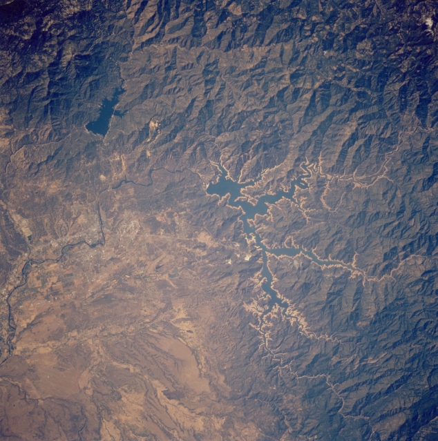 |
| STS064-214-023 Shasta Lake, California, U.S.A. September 1994 Light blue Shasta Lake, part of the Whiskeytown-Shasta-Trinity National Recreation Area, is featured in this near-vertical photograph. Surrounded by Shasta-Trinity National Forest, Shasta Lake is drained by the Sacramento River, which is visible near the center of the photograph and extends to the lower left. The darker blue waters of Whiskeytown Lake and parts of Redding are apparent west of Shasta Lake. |
| Images: | All Available Images Low-Resolution 372k |
|
| Mission: | STS064 |
|
| Roll - Frame: | 214 - 23 |
|
| Geographical Name: | USA-CALIFORNIA |
|
| Features: | REDDING, SHASTA LAKE,MTS |
|
| Center Lat x Lon: | 40.5N x 122.5W |
|
| Film Exposure: | N | N=Normal exposure, U=Under exposed, O=Over exposed, F=out of Focus |
| Percentage of Cloud Cover-CLDP: | 0 |
|
| Camera:: | HB |
|
| Camera Tilt: | 13 | LO=Low Oblique, HO=High Oblique, NV=Near Vertical |
| Camera Focal Length: | 250 |
|
| Nadir to Photo Center Direction: | E | The direction from the nadir to the center point, N=North, S=South, E=East, W=West |
| Stereo?: | N | Y=Yes there is an adjacent picture of the same area, N=No there isn't |
| Orbit Number: | 130 |
|
| Date: | 19940917 | YYYYMMDD |
| Time: | 230619 | GMT HHMMSS |
| Nadir Lat: | 40.6N |
Latitude of suborbital point of spacecraft |
| Nadir Lon: | 123W |
Longitude of suborbital point of spacecraft |
| Sun Azimuth: | 239 | Clockwise angle in degrees from north to the sun measured at the nadir point |
| Space Craft Altitude: | 129 | nautical miles |
| Sun Elevation: | 34 | Angle in degrees between the horizon and the sun, measured at the nadir point |
| Land Views: | MOUNTAIN, FOREST, VALLEY |
|
| Water Views: | LAKE |
|
| Atmosphere Views: | |
|
| Man Made Views: | |
|
| City Views: | |
|
Photo is not associated with any sequences | ||
| NASA Home Page |
JSC Home Page |
JSC Digital Image Collection |
Earth Science & Remote Sensing |
|
This service is provided by the International Space Station program and the JSC Earth Science & Remote Sensing Unit, ARES Division, Exploration Integration Science Directorate.

|