
Geographic Region: USA-MINNESOTA
Feature: L. SUPERIOR, DULUTH, SED
|
Geographic Region: USA-MINNESOTA Feature: L. SUPERIOR, DULUTH, SED |
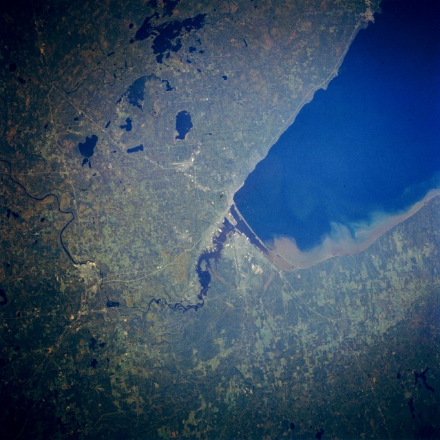 |
| STS064-213-084 Duluth/Superior Area, Minnesota September 1994 The twin cities of Duluth, Minnesota and Superior, Wisconsin (center of the image) can be seen in this northeast-looking view. The blue-colored waters of Lake Superior, one of the largest fresh water lakes in the world and the deepest of the five Great Lakes, cover the upper right quadrant of the image. Situated to the south of Duluth, Superior is located at the mouths of the St. Louis and Nemadji Rivers. The city has a superb natural harbor and shared with Duluth, has some of the United States largest coal and ore docks. Superior has shipyards, high grain elevators, oil refineries, and a large dairy products industry. Superior's sister-city of Duluth is a commercial, industrial, and cultural center for northern Minnesota and northwestern Wisconsin. The city is built largely on rock bluffs overlooking Lake Superior. Duluth is the chief ore shipping point for the United States steel mills. The city is also a leading exporter of grains. Near the top center of the image, Island Lake Reservoir is visible. To the south of Island Lake Reservoir, are the hooked-looking Fish Lake and the rather oblong-shaped Wild Rice Lake. |
| Images: | All Available Images Low-Resolution 131k |
|
| Mission: | STS064 |
|
| Roll - Frame: | 213 - 84 |
|
| Geographical Name: | USA-MINNESOTA |
|
| Features: | L. SUPERIOR, DULUTH, SED |
|
| Center Lat x Lon: | 46.5N x 92W |
|
| Film Exposure: | N | N=Normal exposure, U=Under exposed, O=Over exposed, F=out of Focus |
| Percentage of Cloud Cover-CLDP: | 0 |
|
| Camera:: | HB |
|
| Camera Tilt: | 47 | LO=Low Oblique, HO=High Oblique, NV=Near Vertical |
| Camera Focal Length: | 250 |
|
| Nadir to Photo Center Direction: | E | The direction from the nadir to the center point, N=North, S=South, E=East, W=West |
| Stereo?: | N | Y=Yes there is an adjacent picture of the same area, N=No there isn't |
| Orbit Number: | 145 |
|
| Date: | 19940918 | YYYYMMDD |
| Time: | 212742 | GMT HHMMSS |
| Nadir Lat: | 46.6N |
Latitude of suborbital point of spacecraft |
| Nadir Lon: | 94.3W |
Longitude of suborbital point of spacecraft |
| Sun Azimuth: | 239 | Clockwise angle in degrees from north to the sun measured at the nadir point |
| Space Craft Altitude: | 129 | nautical miles |
| Sun Elevation: | 28 | Angle in degrees between the horizon and the sun, measured at the nadir point |
| Land Views: | FOREST, HILL |
|
| Water Views: | LAKE, RIVER |
|
| Atmosphere Views: | |
|
| Man Made Views: | URBAN AREA |
|
| City Views: | |
|
Photo is not associated with any sequences | ||
| NASA Home Page |
JSC Home Page |
JSC Digital Image Collection |
Earth Science & Remote Sensing |
|
This service is provided by the International Space Station program and the JSC Earth Science & Remote Sensing Unit, ARES Division, Exploration Integration Science Directorate.

|