
Geographic Region: USA-ARIZONA
Feature: PHOENIX, LAKE PLEASANT
|
Geographic Region: USA-ARIZONA Feature: PHOENIX, LAKE PLEASANT |
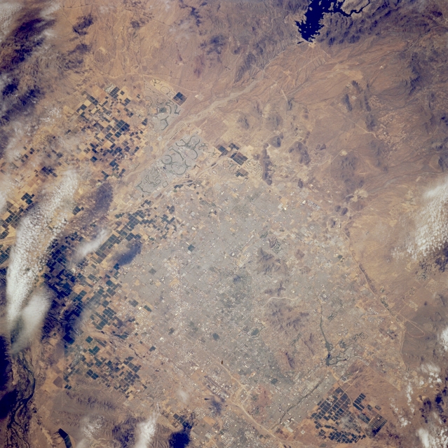 |
| STS064-213-073 Phoenix Area, Arizona, U.S.A. September 1994 Clouds and shadows obscure part of the dark, rectangular, irrigated field patterns west, southwest, and east of urban Phoenix. Residential, commercial, and industrial concentrations are hard to distinguish; however, Sun City, a retirement community northwest of Phoenix, is easily recognized because of its darker, circular features (golf courses, reservoirs, and parks). U.S. Highway 60 (Grand Avenue) traverses Sun City and the west side of Phoenix in a generally northwest-southeast direction. Lake Pleasant and its dam are clearly visible, and the Agua Fria River flows almost due south from Lake Pleasant, west of Phoenix, to the Gila River. Small South Mountain, south of Phoenix, and other hills and low mountains appear as various shades of brown. |
| Images: | All Available Images Low-Resolution 369k |
|
| Mission: | STS064 |
|
| Roll - Frame: | 213 - 73 |
|
| Geographical Name: | USA-ARIZONA |
|
| Features: | PHOENIX, LAKE PLEASANT |
|
| Center Lat x Lon: | 33.5N x 112W |
|
| Film Exposure: | N | N=Normal exposure, U=Under exposed, O=Over exposed, F=out of Focus |
| Percentage of Cloud Cover-CLDP: | 10 |
|
| Camera:: | HB |
|
| Camera Tilt: | 22 | LO=Low Oblique, HO=High Oblique, NV=Near Vertical |
| Camera Focal Length: | 250 |
|
| Nadir to Photo Center Direction: | NW | The direction from the nadir to the center point, N=North, S=South, E=East, W=West |
| Stereo?: | Y | Y=Yes there is an adjacent picture of the same area, N=No there isn't |
| Orbit Number: | 145 |
|
| Date: | 19940918 | YYYYMMDD |
| Time: | 212252 | GMT HHMMSS |
| Nadir Lat: | 33.0N |
Latitude of suborbital point of spacecraft |
| Nadir Lon: | 111.3W |
Longitude of suborbital point of spacecraft |
| Sun Azimuth: | 229 | Clockwise angle in degrees from north to the sun measured at the nadir point |
| Space Craft Altitude: | 129 | nautical miles |
| Sun Elevation: | 47 | Angle in degrees between the horizon and the sun, measured at the nadir point |
| Land Views: | DESERT |
|
| Water Views: | RIVER |
|
| Atmosphere Views: | |
|
| Man Made Views: | URBAN AREA, AGRICULTURE |
|
| City Views: | PHOENIX |
|
Photo is not associated with any sequences | ||
| NASA Home Page |
JSC Home Page |
JSC Digital Image Collection |
Earth Science & Remote Sensing |
|
This service is provided by the International Space Station program and the JSC Earth Science & Remote Sensing Unit, ARES Division, Exploration Integration Science Directorate.

|