
Geographic Region: USA-CALIFORNIA
Feature: EDWARDS AFB, MOJAVE DES.
|
Geographic Region: USA-CALIFORNIA Feature: EDWARDS AFB, MOJAVE DES. |
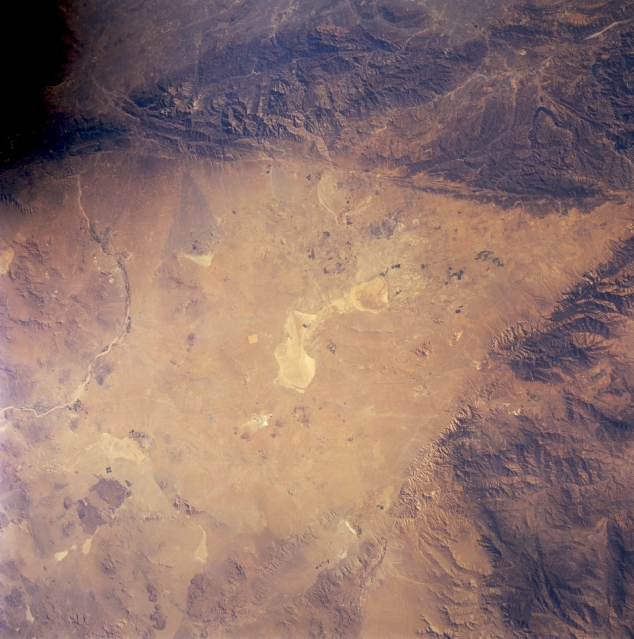 |
| STS064-212-066 Mojave Desert, California, U.S.A. September 1994 The V-shaped west end of the Mojave Desert and highly reflective Rogers Dry Lake are captured in this synoptic photograph. Rogers Dry Lake, situated within Edwards Air Force Base, is an alternate landing site for NASA Space Shuttles. The northwest-southeast-trending San Andreas Fault and the northeast-southwest-trending Garlock Fault intersect at the western apex of the desert. Sediment transported from the San Gabriel Mountains and deposited along the southern Mojave Desert is highlighted by the subtle colors of the alluvial fans. Evident is the gentle curve of the intermittently flowing Mojave River. |
| Images: | All Available Images Low-Resolution 324k |
|
| Mission: | STS064 |
|
| Roll - Frame: | 212 - 66 |
|
| Geographical Name: | USA-CALIFORNIA |
|
| Features: | EDWARDS AFB, MOJAVE DES. |
|
| Center Lat x Lon: | 35.0N x 118W |
|
| Film Exposure: | N | N=Normal exposure, U=Under exposed, O=Over exposed, F=out of Focus |
| Percentage of Cloud Cover-CLDP: | 0 |
|
| Camera:: | HB |
|
| Camera Tilt: | LO | LO=Low Oblique, HO=High Oblique, NV=Near Vertical |
| Camera Focal Length: | 100 |
|
| Nadir to Photo Center Direction: | The direction from the nadir to the center point, N=North, S=South, E=East, W=West |
|
| Stereo?: | Y | Y=Yes there is an adjacent picture of the same area, N=No there isn't |
| Orbit Number: | |
|
| Date: | 199409__ | YYYYMMDD |
| Time: | GMT HHMMSS |
|
| Nadir Lat: | N |
Latitude of suborbital point of spacecraft |
| Nadir Lon: | E |
Longitude of suborbital point of spacecraft |
| Sun Azimuth: | Clockwise angle in degrees from north to the sun measured at the nadir point |
|
| Space Craft Altitude: | nautical miles |
|
| Sun Elevation: | Angle in degrees between the horizon and the sun, measured at the nadir point |
|
| Land Views: | MOUNTAIN, FAULT, DESERT |
|
| Water Views: | |
|
| Atmosphere Views: | |
|
| Man Made Views: | |
|
| City Views: | |
|
Photo is not associated with any sequences | ||
| NASA Home Page |
JSC Home Page |
JSC Digital Image Collection |
Earth Science & Remote Sensing |
|
This service is provided by the International Space Station program and the JSC Earth Science & Remote Sensing Unit, ARES Division, Exploration Integration Science Directorate.

|