
Geographic Region: USA-CALIFORNIA
Feature: CLEAR LAKE, COAST RANGE
|
Geographic Region: USA-CALIFORNIA Feature: CLEAR LAKE, COAST RANGE |
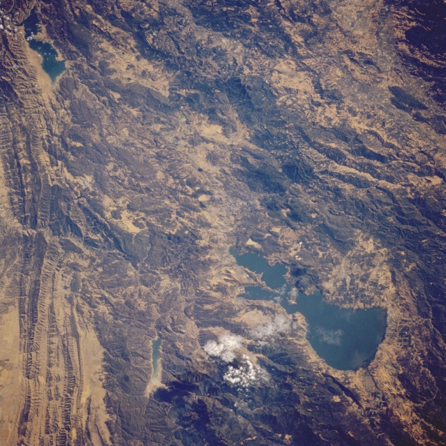 |
| STS064-210-028 Clear Lake and Coast Range, California, U.S.A. September 1994 The blue waters of Clear Lake, the largest freshwater lake entirely within the state of California, and the terrain of the Coast Range are apparent in this low-oblique, south-looking photograph. Visible are Clear Lake, a major tourist and fishing resort 25 miles (40 kilometers) long and 2 to 10 miles (3 to 16 kilometers) wide, and Lake Berryessa, another popular tourist resort, near the top left. Hogback ridges traverse north-south, and timber-covered Mendocino National Forest is visible near the bottom center to bottom right. |
| Images: | All Available Images Low-Resolution 400k |
|
| Mission: | STS064 |
|
| Roll - Frame: | 210 - 28 |
|
| Geographical Name: | USA-CALIFORNIA |
|
| Features: | CLEAR LAKE, COAST RANGE |
|
| Center Lat x Lon: | 39.0N x 122.5W |
|
| Film Exposure: | N | N=Normal exposure, U=Under exposed, O=Over exposed, F=out of Focus |
| Percentage of Cloud Cover-CLDP: | 5 |
|
| Camera:: | HB |
|
| Camera Tilt: | 35 | LO=Low Oblique, HO=High Oblique, NV=Near Vertical |
| Camera Focal Length: | 250 |
|
| Nadir to Photo Center Direction: | SE | The direction from the nadir to the center point, N=North, S=South, E=East, W=West |
| Stereo?: | Y | Y=Yes there is an adjacent picture of the same area, N=No there isn't |
| Orbit Number: | 130 |
|
| Date: | 19940917 | YYYYMMDD |
| Time: | 230616 | GMT HHMMSS |
| Nadir Lat: | 40.3N |
Latitude of suborbital point of spacecraft |
| Nadir Lon: | 123.3W |
Longitude of suborbital point of spacecraft |
| Sun Azimuth: | 238 | Clockwise angle in degrees from north to the sun measured at the nadir point |
| Space Craft Altitude: | 129 | nautical miles |
| Sun Elevation: | 34 | Angle in degrees between the horizon and the sun, measured at the nadir point |
| Land Views: | MOUNTAIN, FAULT, FOREST |
|
| Water Views: | LAKE |
|
| Atmosphere Views: | |
|
| Man Made Views: | |
|
| City Views: | |
|
Photo is not associated with any sequences | ||
| NASA Home Page |
JSC Home Page |
JSC Digital Image Collection |
Earth Science & Remote Sensing |
|
This service is provided by the International Space Station program and the JSC Earth Science & Remote Sensing Unit, ARES Division, Exploration Integration Science Directorate.

|