
Geographic Region: CANADA-O
Feature: CLOUDS, HAZE
|
Geographic Region: CANADA-O Feature: CLOUDS, HAZE |
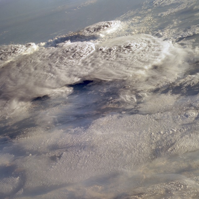 |
| STS064-205-050 Supercell Thunderstorms, Canada September 1994 A cluster of large supercell thunderstorms, located near the border between Manitoba and Ontario, Canada, and Minnesota, United States can be seen in this low-oblique view. In North America, most supercell thunderstorms occur over the Great Plains of the United States and southern Canada, where moist, warm, tropical air from the Gulf of Mexico clashes with dryer, cooler, polar air from the Canadian Arctic. Such storms can produce violent downdrafts with locally strong and sometimes destructive winds. Storms of this magnitude can also produce hail and in many cases, tornadoes. A thunderstorm is an intense local storm associated with a tall, dense cumulonimbus cloud in which there are very strong updrafts of air. They occur when the atmosphere is unstable and moist warm air is abundant and becomes buoyant near the ground. The towering cumulonimbus thunderheads can rise through the stratosphere to altitudes of 12.5 miles (20 km); they penetrate the upper cirrus cloud layer in this view. |
| Images: | All Available Images Low-Resolution 118k |
|
| Mission: | STS064 |
|
| Roll - Frame: | 205 - 50 |
|
| Geographical Name: | CANADA-O |
|
| Features: | CLOUDS, HAZE |
|
| Center Lat x Lon: | N x E |
|
| Film Exposure: | N | N=Normal exposure, U=Under exposed, O=Over exposed, F=out of Focus |
| Percentage of Cloud Cover-CLDP: | 80 |
|
| Camera:: | HB |
|
| Camera Tilt: | LO | LO=Low Oblique, HO=High Oblique, NV=Near Vertical |
| Camera Focal Length: | 250 |
|
| Nadir to Photo Center Direction: | The direction from the nadir to the center point, N=North, S=South, E=East, W=West |
|
| Stereo?: | Y | Y=Yes there is an adjacent picture of the same area, N=No there isn't |
| Orbit Number: | 66 |
|
| Date: | 19940913 | YYYYMMDD |
| Time: | 234419 | GMT HHMMSS |
| Nadir Lat: | 49.6N |
Latitude of suborbital point of spacecraft |
| Nadir Lon: | 93.9W |
Longitude of suborbital point of spacecraft |
| Sun Azimuth: | 267 | Clockwise angle in degrees from north to the sun measured at the nadir point |
| Space Craft Altitude: | 139 | nautical miles |
| Sun Elevation: | 7 | Angle in degrees between the horizon and the sun, measured at the nadir point |
| Land Views: | |
|
| Water Views: | |
|
| Atmosphere Views: | THUNDERSTORM |
|
| Man Made Views: | |
|
| City Views: | |
|
Photo is not associated with any sequences | ||
| NASA Home Page |
JSC Home Page |
JSC Digital Image Collection |
Earth Science & Remote Sensing |
|
This service is provided by the International Space Station program and the JSC Earth Science & Remote Sensing Unit, ARES Division, Exploration Integration Science Directorate.

|