
Geographic Region: USA-CALIFORNIA
Feature: MOUNT SHASTA, COAST RA.
|
Geographic Region: USA-CALIFORNIA Feature: MOUNT SHASTA, COAST RA. |
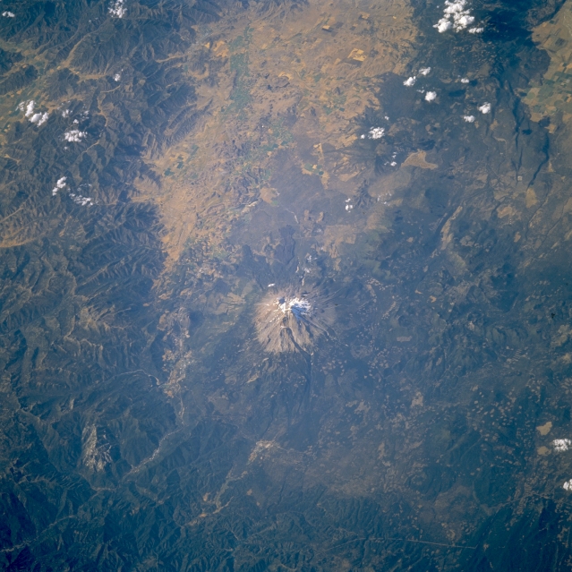 |
| STS064-115-071 Mount Shasta, California, U.S.A. September 1994 Mount Shasta, whose last known eruption was in 1786, is the large stratovolcano featured in this north-looking, low-oblique photograph. Located in northern California in the southern Cascade Range, the glacier-crowned peak of Mount Shasta at 14 162 feet (4319 meters) is actually two volcanic mountains grown together to become one of the world's largest volcanoes. Shastina, the smaller of the two peaks at more than 12 000 feet (3660 meters), is located northwest of Shasta, the larger peak, at the summit. Other features visible in the photograph near Mount Shasta are the Klamath Mountains to the west and northwest and the wide Shasta River Valley to the north. |
| Images: | All Available Images Low-Resolution 349k |
|
| Mission: | STS064 |
|
| Roll - Frame: | 115 - 71 |
|
| Geographical Name: | USA-CALIFORNIA |
|
| Features: | MOUNT SHASTA, COAST RA. |
|
| Center Lat x Lon: | 41.5N x 122W |
|
| Film Exposure: | N | N=Normal exposure, U=Under exposed, O=Over exposed, F=out of Focus |
| Percentage of Cloud Cover-CLDP: | 5 |
|
| Camera:: | HB |
|
| Camera Tilt: | 42 | LO=Low Oblique, HO=High Oblique, NV=Near Vertical |
| Camera Focal Length: | 250 |
|
| Nadir to Photo Center Direction: | NW | The direction from the nadir to the center point, N=North, S=South, E=East, W=West |
| Stereo?: | N | Y=Yes there is an adjacent picture of the same area, N=No there isn't |
| Orbit Number: | 114 |
|
| Date: | 19940916 | YYYYMMDD |
| Time: | 231744 | GMT HHMMSS |
| Nadir Lat: | 40.3N |
Latitude of suborbital point of spacecraft |
| Nadir Lon: | 120.5W |
Longitude of suborbital point of spacecraft |
| Sun Azimuth: | 244 | Clockwise angle in degrees from north to the sun measured at the nadir point |
| Space Craft Altitude: | 129 | nautical miles |
| Sun Elevation: | 31 | Angle in degrees between the horizon and the sun, measured at the nadir point |
| Land Views: | MOUNTAIN, VOLCANO, MOUNTAIN, VALLEY, FOREST, CRATER |
|
| Water Views: | RIVER |
|
| Atmosphere Views: | |
|
| Man Made Views: | AGRICULTURE, DEFORESTATION |
|
| City Views: | |
|
Photo is not associated with any sequences | ||
| NASA Home Page |
JSC Home Page |
JSC Digital Image Collection |
Earth Science & Remote Sensing |
|
This service is provided by the International Space Station program and the JSC Earth Science & Remote Sensing Unit, ARES Division, Exploration Integration Science Directorate.

|