Geographic Region: REPUBLIC SOUTH AFRICA
Feature: CAPE TOWN, SMOKE,SUNGLINT
|
Geographic Region: REPUBLIC SOUTH AFRICA Feature: CAPE TOWN, SMOKE,SUNGLINT |
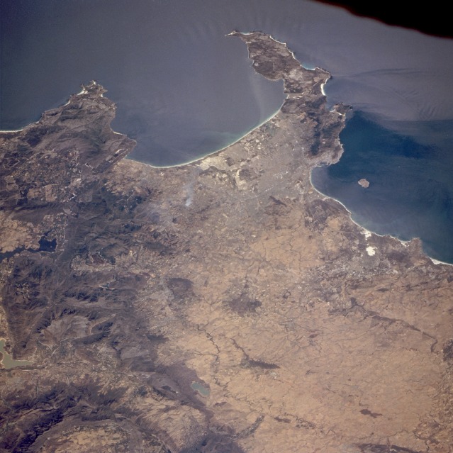 |
| STS063-704-073 Cape Town, Republic of South Africa January 1995 Cape Town, considered to be one of the great scenic cities of the world, is captured in this southwest-looking, low-oblique photograph. In the Republic of South Africa, Cape Town is second to Johannesburg in population and second to Durban as a port and industrial center. The city, situated in the southwestern part of the Cape Province, lies at the foot of Table Mountain [3567 feet (1088 meters) in altitude] on the shore of Table Bay, in which lies Robben Island. Because the mountains obstruct inland expansion, the city has developed along the coast--its western suburbs fronting Table Bay and its southern suburbs fronting False Bay. Agricultural areas (brownish-tan) stretch northward from the city along the coastal plain. Food processing, wine making, and clothing manufacturing are the city's most important industries. Other industries include motor vehicle plants, shoe manufacturing, tourism, printing, oil, and engineering. Cape Town is often called the "Mother City of South Africa" because of its historical significance. The Cape of Good Hope appears at the southern tip of the peninsula. |
| Images: | All Available Images Low-Resolution 120k |
|
| Mission: | STS063 |
|
| Roll - Frame: | 704 - 73 |
|
| Geographical Name: | REPUBLIC SOUTH AFRICA |
|
| Features: | CAPE TOWN, SMOKE,SUNGLINT |
|
| Center Lat x Lon: | 34S x 18.5E |
|
| Film Exposure: | N | N=Normal exposure, U=Under exposed, O=Over exposed, F=out of Focus |
| Percentage of Cloud Cover-CLDP: | 0 |
|
| Camera:: | HB |
|
| Camera Tilt: | LO=Low Oblique, HO=High Oblique, NV=Near Vertical |
|
| Camera Focal Length: | 100 |
|
| Nadir to Photo Center Direction: | The direction from the nadir to the center point, N=North, S=South, E=East, W=West |
|
| Stereo?: | Y | Y=Yes there is an adjacent picture of the same area, N=No there isn't |
| Orbit Number: | |
|
| Date: | 199502__ | YYYYMMDD |
| Time: | GMT HHMMSS |
|
| Nadir Lat: | N |
Latitude of suborbital point of spacecraft |
| Nadir Lon: | E |
Longitude of suborbital point of spacecraft |
| Sun Azimuth: | Clockwise angle in degrees from north to the sun measured at the nadir point |
|
| Space Craft Altitude: | nautical miles |
|
| Sun Elevation: | Angle in degrees between the horizon and the sun, measured at the nadir point |
|
| Land Views: | CAPE, PENINSULA, COAST, MOUNTAIN |
|
| Water Views: | LAKE, OCEAN, BAY |
|
| Atmosphere Views: | |
|
| Man Made Views: | URBAN AREA, AGRICULTURE |
|
| City Views: | |
|
Photo is not associated with any sequences | ||
| NASA Home Page |
JSC Home Page |
JSC Digital Image Collection |
Earth Science & Remote Sensing |
|
This service is provided by the International Space Station program and the JSC Earth Science & Remote Sensing Unit, ARES Division, Exploration Integration Science Directorate.

|