
Geographic Region: USA-NEW MEXICO
Feature: LAS VEGAS, SANTA FE, MTS
|
Geographic Region: USA-NEW MEXICO Feature: LAS VEGAS, SANTA FE, MTS |
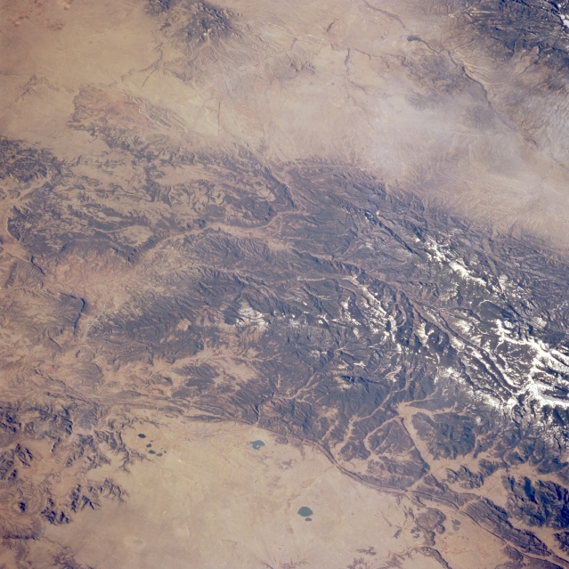 |
| STS062-098-097 Santa Fe Trail, New Mexico, U.S.A. March 1994 The southern tip of the forested and partially snow-covered Sangre de Cristo Mountains occupies much of this low-oblique, southwest-looking photograph. The two roughly oval, dark lakes and reservoirs (bottom center of the photograph) pinpoint Las Vegas, while Santa Fe appears to the west along the southwestern edge of the Sangre de Cristo Mountains. Interstate Highway 25, formerly known as the Santa Fe Trail, connects these two cities as it winds along the southern tip of the mountains. The north-south aligned canyon in the middle of the mountains is the headwater area of the Pecos River. A small section of the Rio Grande and its rift system are visible (upper right corner). |
| Images: | All Available Images Low-Resolution 352k |
|
| Mission: | STS062 |
|
| Roll - Frame: | 98 - 97 |
|
| Geographical Name: | USA-NEW MEXICO |
|
| Features: | LAS VEGAS, SANTA FE, MTS |
|
| Center Lat x Lon: | 35.5N x 105.5W |
|
| Film Exposure: | N | N=Normal exposure, U=Under exposed, O=Over exposed, F=out of Focus |
| Percentage of Cloud Cover-CLDP: | 0 |
|
| Camera:: | HB |
|
| Camera Tilt: | 47 | LO=Low Oblique, HO=High Oblique, NV=Near Vertical |
| Camera Focal Length: | 250 |
|
| Nadir to Photo Center Direction: | W | The direction from the nadir to the center point, N=North, S=South, E=East, W=West |
| Stereo?: | Y | Y=Yes there is an adjacent picture of the same area, N=No there isn't |
| Orbit Number: | 34 |
|
| Date: | 19940306 | YYYYMMDD |
| Time: | 154556 | GMT HHMMSS |
| Nadir Lat: | 35.9N |
Latitude of suborbital point of spacecraft |
| Nadir Lon: | 102.7W |
Longitude of suborbital point of spacecraft |
| Sun Azimuth: | 121 | Clockwise angle in degrees from north to the sun measured at the nadir point |
| Space Craft Altitude: | 161 | nautical miles |
| Sun Elevation: | 28 | Angle in degrees between the horizon and the sun, measured at the nadir point |
| Land Views: | MOUNTAIN |
|
| Water Views: | |
|
| Atmosphere Views: | |
|
| Man Made Views: | |
|
| City Views: | |
|
Photo is not associated with any sequences | ||
| NASA Home Page |
JSC Home Page |
JSC Digital Image Collection |
Earth Science & Remote Sensing |
|
This service is provided by the International Space Station program and the JSC Earth Science & Remote Sensing Unit, ARES Division, Exploration Integration Science Directorate.

|