
Geographic Region: USA-NORTH CAROLINA
Feature: DURHAM, RALEIGH, AGRICULTURE
|
Geographic Region: USA-NORTH CAROLINA Feature: DURHAM, RALEIGH, AGRICULTURE |
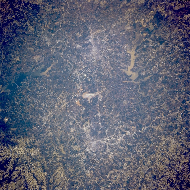 |
| STS062-098-071 Raleigh-Durham Area, North Carolina, U.S.A. March 1994 Although the general quality of this image lacks definition in terms of discriminating some individual features, the metropolitan area of Raleigh (bottom center) and Durham (top center) can be discerned by their concentrated, highly reflective downtown areas. The straight linear feature connecting Raleigh and Durham is U. S. Highway 70. The winding thin line south-southwest of Durham is Interstate Highway 40. The Raleigh-Durham International Airport can be identified as the bright, linear feature, located midway between these cities (center of picture). The light colored, muddy looking lake northeast of Durham is Falls Lake Reservoir and the darker colored reservoir south of Durham is B. Everett Jordan Lake. The mottled looking terrain throughout this image shows a mixture of agriculture (lighter tones) and forested lands (darker area). |
| Images: | All Available Images Low-Resolution 425k |
|
| Mission: | STS062 |
|
| Roll - Frame: | 98 - 71 |
|
| Geographical Name: | USA-NORTH CAROLINA |
|
| Features: | DURHAM, RALEIGH, AGRICULTURE |
|
| Center Lat x Lon: | 36.0N x 79W |
|
| Film Exposure: | N | N=Normal exposure, U=Under exposed, O=Over exposed, F=out of Focus |
| Percentage of Cloud Cover-CLDP: | 0 |
|
| Camera:: | HB |
|
| Camera Tilt: | 11 | LO=Low Oblique, HO=High Oblique, NV=Near Vertical |
| Camera Focal Length: | 100 |
|
| Nadir to Photo Center Direction: | W | The direction from the nadir to the center point, N=North, S=South, E=East, W=West |
| Stereo?: | N | Y=Yes there is an adjacent picture of the same area, N=No there isn't |
| Orbit Number: | 33 |
|
| Date: | 19940306 | YYYYMMDD |
| Time: | 141547 | GMT HHMMSS |
| Nadir Lat: | 36.2N |
Latitude of suborbital point of spacecraft |
| Nadir Lon: | 78.5W |
Longitude of suborbital point of spacecraft |
| Sun Azimuth: | 123 | Clockwise angle in degrees from north to the sun measured at the nadir point |
| Space Craft Altitude: | 161 | nautical miles |
| Sun Elevation: | 29 | Angle in degrees between the horizon and the sun, measured at the nadir point |
| Land Views: | |
|
| Water Views: | LAKE, RESERVOIR |
|
| Atmosphere Views: | |
|
| Man Made Views: | HIGHWAY, AIRPORT, URBAN AREA |
|
| City Views: | |
|
Photo is not associated with any sequences | ||
| NASA Home Page |
JSC Home Page |
JSC Digital Image Collection |
Earth Science & Remote Sensing |
|
This service is provided by the International Space Station program and the JSC Earth Science & Remote Sensing Unit, ARES Division, Exploration Integration Science Directorate.

|