
Geographic Region: USA-FLORIDA
Feature: PENSACOLA, BAY, AGRICULTURE
|
Geographic Region: USA-FLORIDA Feature: PENSACOLA, BAY, AGRICULTURE |
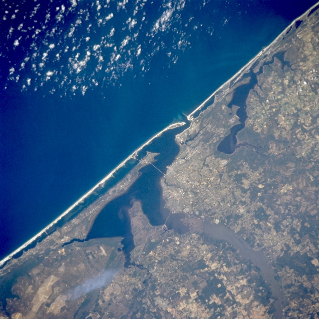 |
| STS062-098-171 Pensacola, Florida, U.S.A. March 1994 The highly reflective, sandy beaches that are characteristic of the Florida panhandle barrier islands are evident in this synoptic photograph. Discernible are the general outline of the city on land that juts southeast to Escambia and Pensacola Bays; the south-flowing Escambia River with its vegetated floodplain and delta (lower right corner); and large, cultivated fields east of Escambia Bay (bottom center). The Perdido River and Perdido Bay, immediately west of Pensacola, form the Alabama-Florida panhandle border. A narrow peninsula that extends westward and separates Pensacola Bay from the Intracoastal Waterway roughly parallels Santa Rosa Island, a sandy barrier island, and the east-west-oriented lagoon that separates the island from the mainland. |
| Images: | All Available Images Low-Resolution 359k |
|
| Mission: | STS062 |
|
| Roll - Frame: | 98 - 171 |
|
| Geographical Name: | USA-FLORIDA |
|
| Features: | PENSACOLA, BAY, AGRICULTURE |
|
| Center Lat x Lon: | 30.5N x 87.5W |
|
| Film Exposure: | N | N=Normal exposure, U=Under exposed, O=Over exposed, F=out of Focus |
| Percentage of Cloud Cover-CLDP: | 5 |
|
| Camera:: | HB |
|
| Camera Tilt: | 33 | LO=Low Oblique, HO=High Oblique, NV=Near Vertical |
| Camera Focal Length: | 250 |
|
| Nadir to Photo Center Direction: | N | The direction from the nadir to the center point, N=North, S=South, E=East, W=West |
| Stereo?: | Y | Y=Yes there is an adjacent picture of the same area, N=No there isn't |
| Orbit Number: | 130 |
|
| Date: | 19940312 | YYYYMMDD |
| Time: | 164022 | GMT HHMMSS |
| Nadir Lat: | 28.8N |
Latitude of suborbital point of spacecraft |
| Nadir Lon: | 87.2W |
Longitude of suborbital point of spacecraft |
| Sun Azimuth: | 146 | Clockwise angle in degrees from north to the sun measured at the nadir point |
| Space Craft Altitude: | 161 | nautical miles |
| Sun Elevation: | 53 | Angle in degrees between the horizon and the sun, measured at the nadir point |
| Land Views: | PLAIN, PENINSULA |
|
| Water Views: | RIVER, GULF, BAY, DELTA |
|
| Atmosphere Views: | |
|
| Man Made Views: | URBAN AREA, AGRICULTURE |
|
| City Views: | |
|
Photo is not associated with any sequences | ||
| NASA Home Page |
JSC Home Page |
JSC Digital Image Collection |
Earth Science & Remote Sensing |
|
This service is provided by the International Space Station program and the JSC Earth Science & Remote Sensing Unit, ARES Division, Exploration Integration Science Directorate.

|