 Photo #: STS062-98-158 Date: Mar. 1994
Geographic Region: USA-CALIFORNIA
Feature: MERCED, RES., AGRICULTURE, VALLEY
|
Photo #: STS062-98-158 Date: Mar. 1994 Geographic Region: USA-CALIFORNIA Feature: MERCED, RES., AGRICULTURE, VALLEY |
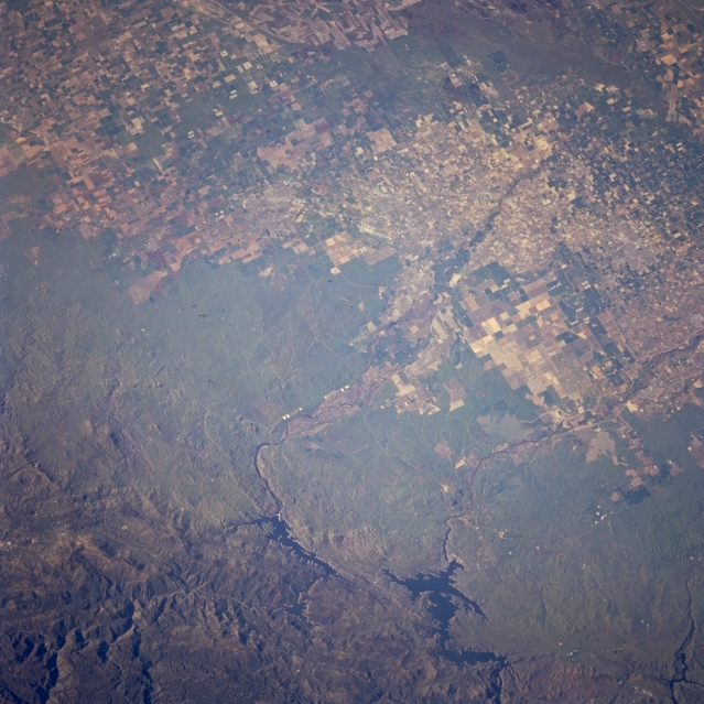 |
| STS062-098-158 San Joaquin Valley, Lake McClure, and Don Pedro Reservoir, California, U.S.A. March 1994 The agriculturally rich San Joaquin Valley is captured in this low-oblique, north-northeast-looking photograph. The boundary is distinct between agricultural field patterns of the valley and the grass- and scrub-covered alluvial fan, which becomes more tree covered as the altitude of the Sierra Nevada Mountains increases. Two large reservoirs--broader and more northerly Don Pedro Reservoir, fed and drained by the Tuolumne River, and narrower and more southerly Lake McClure, fed and drained by the Merced River--modify the valley's water flow for drinking water and crop irrigation. The higher Sierra Nevada Mountains are visible to the east. |
| Images: | All Available Images Low-Resolution 352k |
|
| Mission: | STS062 |
|
| Roll - Frame: | 98 - 158 |
|
| Geographical Name: | USA-CALIFORNIA |
|
| Features: | MERCED, RES., AGRICULTURE, VALLEY |
|
| Center Lat x Lon: | 37.5N x 120W |
|
| Film Exposure: | N | N=Normal exposure, U=Under exposed, O=Over exposed, F=out of Focus |
| Percentage of Cloud Cover-CLDP: | 0 |
|
| Camera:: | HB |
|
| Camera Tilt: | 24 | LO=Low Oblique, HO=High Oblique, NV=Near Vertical |
| Camera Focal Length: | 250 |
|
| Nadir to Photo Center Direction: | SW | The direction from the nadir to the center point, N=North, S=South, E=East, W=West |
| Stereo?: | Y | Y=Yes there is an adjacent picture of the same area, N=No there isn't |
| Orbit Number: | 130 |
|
| Date: | 19940312 | YYYYMMDD |
| Time: | 163255 | GMT HHMMSS |
| Nadir Lat: | 38.4N |
Latitude of suborbital point of spacecraft |
| Nadir Lon: | 119.2W |
Longitude of suborbital point of spacecraft |
| Sun Azimuth: | 117 | Clockwise angle in degrees from north to the sun measured at the nadir point |
| Space Craft Altitude: | 160 | nautical miles |
| Sun Elevation: | 26 | Angle in degrees between the horizon and the sun, measured at the nadir point |
| Land Views: | VALLEY, MOUNTAIN |
|
| Water Views: | LAKE |
|
| Atmosphere Views: | |
|
| Man Made Views: | AGRICULTURE |
|
| City Views: | |
|
Photo is not associated with any sequences | ||
| NASA Home Page |
JSC Home Page |
JSC Digital Image Collection |
Earth Science & Remote Sensing |

This service is provided by the International Space Station program and the JSC Earth Science & Remote Sensing Unit, ARES Division, Exploration Integration Science Directorate.
|