
Geographic Region: USA-TEXAS
Feature: GALVESTON BAY
|
Geographic Region: USA-TEXAS Feature: GALVESTON BAY |
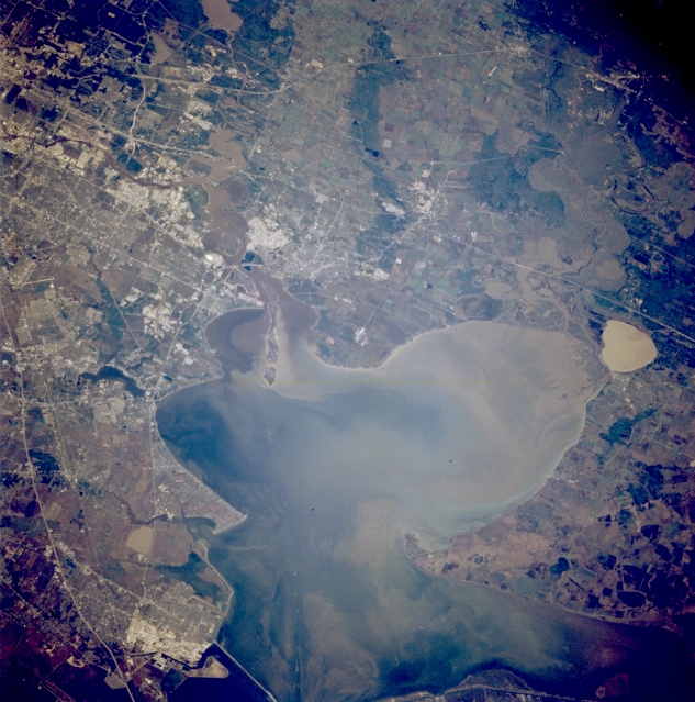 |
| STS062-094-096 Galveston Bay, Texas, U.S.A. March 1994 Interstate Highway 10 exits the urban and industrial areas east of Houston and crosses two floodplains--one created by the San Jacinto River and a wider, swampy one that contains numerous lakes associated with the Trinity River. The northeast extension of Galveston Bay is Trinity Bay, which is really a bay within a bay; complex sediment patterns are discernible in both. Brown, oval Lake Anahuac is just south of Interstate Highway 10. Brighter reflective features show concentrations of petrochemical industries along the Houston Ship Channel and Texas City. |
| Images: | All Available Images Low-Resolution 358k |
|
| Mission: | STS062 |
|
| Roll - Frame: | 94 - 96 |
|
| Geographical Name: | USA-TEXAS |
|
| Features: | GALVESTON BAY |
|
| Center Lat x Lon: | 29.5N x 95W |
|
| Film Exposure: | N | N=Normal exposure, U=Under exposed, O=Over exposed, F=out of Focus |
| Percentage of Cloud Cover-CLDP: | 0 |
|
| Camera:: | HB |
|
| Camera Tilt: | 36 | LO=Low Oblique, HO=High Oblique, NV=Near Vertical |
| Camera Focal Length: | 250 |
|
| Nadir to Photo Center Direction: | N | The direction from the nadir to the center point, N=North, S=South, E=East, W=West |
| Stereo?: | Y | Y=Yes there is an adjacent picture of the same area, N=No there isn't |
| Orbit Number: | 209 |
|
| Date: | 19940317 | YYYYMMDD |
| Time: | 144432 | GMT HHMMSS |
| Nadir Lat: | 28.2N |
Latitude of suborbital point of spacecraft |
| Nadir Lon: | 94.8W |
Longitude of suborbital point of spacecraft |
| Sun Azimuth: | 109 | Clockwise angle in degrees from north to the sun measured at the nadir point |
| Space Craft Altitude: | 109 | nautical miles |
| Sun Elevation: | 29 | Angle in degrees between the horizon and the sun, measured at the nadir point |
| Land Views: | PLAIN |
|
| Water Views: | BAY, LAKE, RIVER, CHANNEL |
|
| Atmosphere Views: | |
|
| Man Made Views: | HIGHWAY, URBAN AREA |
|
| City Views: | |
|
Photo is not associated with any sequences | ||
| NASA Home Page |
JSC Home Page |
JSC Digital Image Collection |
Earth Science & Remote Sensing |
|
This service is provided by the International Space Station program and the JSC Earth Science & Remote Sensing Unit, ARES Division, Exploration Integration Science Directorate.

|