
Geographic Region: USA-TEXAS
Feature: HOUSTON
|
Geographic Region: USA-TEXAS Feature: HOUSTON |
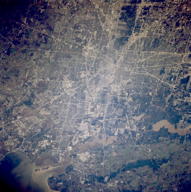 |
| STS062-094-092 Houston, Texas, U.S.A. March 1994 The central business district is the point of convergence of an extensive highway network that services Houston, especially the eastern half of the city, in this west-looking photograph. The highly reflective, heavily industrialized corridor extending eastward from downtown borders the Houston Ship Channel. Much of the internal, grid street network shows a classic checkerboard design. The lower San Jacinto River system that includes muddy Lake Houston flows southward into the northwest corner of Galveston Bay. |
| Images: | All Available Images Low-Resolution 393k |
|
| Mission: | STS062 |
|
| Roll - Frame: | 94 - 92 |
|
| Geographical Name: | USA-TEXAS |
|
| Features: | HOUSTON |
|
| Center Lat x Lon: | 30.0N x 95W |
|
| Film Exposure: | N | N=Normal exposure, U=Under exposed, O=Over exposed, F=out of Focus |
| Percentage of Cloud Cover-CLDP: | 0 |
|
| Camera:: | HB |
|
| Camera Tilt: | 46 | LO=Low Oblique, HO=High Oblique, NV=Near Vertical |
| Camera Focal Length: | 250 |
|
| Nadir to Photo Center Direction: | NE | The direction from the nadir to the center point, N=North, S=South, E=East, W=West |
| Stereo?: | Y | Y=Yes there is an adjacent picture of the same area, N=No there isn't |
| Orbit Number: | 209 |
|
| Date: | 19940317 | YYYYMMDD |
| Time: | 144404 | GMT HHMMSS |
| Nadir Lat: | 29.1N |
Latitude of suborbital point of spacecraft |
| Nadir Lon: | 96.6W |
Longitude of suborbital point of spacecraft |
| Sun Azimuth: | 108 | Clockwise angle in degrees from north to the sun measured at the nadir point |
| Space Craft Altitude: | 108 | nautical miles |
| Sun Elevation: | 27 | Angle in degrees between the horizon and the sun, measured at the nadir point |
| Land Views: | PLAIN |
|
| Water Views: | CHANNEL, RIVER, RESERVOIR |
|
| Atmosphere Views: | |
|
| Man Made Views: | AIRPORT, HIGHWAY, URBAN AREA |
|
| City Views: | |
|
Photo is not associated with any sequences | ||
| NASA Home Page |
JSC Home Page |
JSC Digital Image Collection |
Earth Science & Remote Sensing |
|
This service is provided by the International Space Station program and the JSC Earth Science & Remote Sensing Unit, ARES Division, Exploration Integration Science Directorate.

|