
Geographic Region: USA-KENTUCKY
Feature: LEXINGTON AREA
|
Geographic Region: USA-KENTUCKY Feature: LEXINGTON AREA |
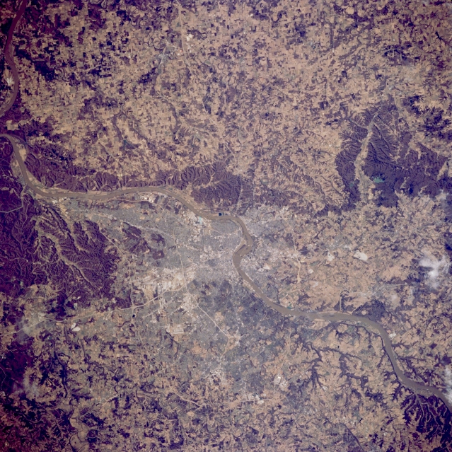 |
| STS062-091-093 Louisville, Kentucky, U.S.A. March 1994 As part of the border between Indiana and Kentucky, the southwest-flowing Ohio River separates New Albany, Indiana (to the north), and Louisville, Kentucky (to the south). Two concentric beltways loop around the south side of Louisville--Interstate Highway 264, the inner belt, and Interstate Highway 265, the outer belt. Louisville developed as a major urban area as a result of Ohio River waterfalls. Goods shipped via the river had to be unloaded before reaching the falls and carried around the falls, thereby creating a need for workers and services. Today ships use locks to navigate the barrier. The dark features throughout the photograph are areas of hilly, eroded, wooded terrain. |
| Images: | All Available Images Low-Resolution 427k |
|
| Mission: | STS062 |
|
| Roll - Frame: | 91 - 93 |
|
| Geographical Name: | USA-KENTUCKY |
|
| Features: | LEXINGTON AREA |
|
| Center Lat x Lon: | 38.0N x 84.5W |
|
| Film Exposure: | N | N=Normal exposure, U=Under exposed, O=Over exposed, F=out of Focus |
| Percentage of Cloud Cover-CLDP: | 0 |
|
| Camera:: | HB |
|
| Camera Tilt: | 9 | LO=Low Oblique, HO=High Oblique, NV=Near Vertical |
| Camera Focal Length: | 100 |
|
| Nadir to Photo Center Direction: | E | The direction from the nadir to the center point, N=North, S=South, E=East, W=West |
| Stereo?: | Y | Y=Yes there is an adjacent picture of the same area, N=No there isn't |
| Orbit Number: | 35 |
|
| Date: | 19940306 | YYYYMMDD |
| Time: | 172457 | GMT HHMMSS |
| Nadir Lat: | 38.1N |
Latitude of suborbital point of spacecraft |
| Nadir Lon: | 84.9W |
Longitude of suborbital point of spacecraft |
| Sun Azimuth: | 171 | Clockwise angle in degrees from north to the sun measured at the nadir point |
| Space Craft Altitude: | 161 | nautical miles |
| Sun Elevation: | 46 | Angle in degrees between the horizon and the sun, measured at the nadir point |
| Land Views: | HILL |
|
| Water Views: | RIVER |
|
| Atmosphere Views: | |
|
| Man Made Views: | HIGHWAY, URBAN AREA |
|
| City Views: | LOUISVILLE |
|
Photo is not associated with any sequences | ||
| NASA Home Page |
JSC Home Page |
JSC Digital Image Collection |
Earth Science & Remote Sensing |
|
This service is provided by the International Space Station program and the JSC Earth Science & Remote Sensing Unit, ARES Division, Exploration Integration Science Directorate.

|