
Geographic Region: SPAIN
Feature: EBRO R. DELTA AREA
|
Geographic Region: SPAIN Feature: EBRO R. DELTA AREA |
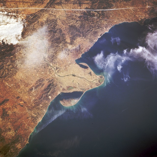 |
| STS062-090-041 Ebro River Delta, Spain March 1994 This low-oblique, north-looking photograph shows the mouth of the Ebro River, the second longest river in Spain. The Ebro rises in the Cantabria Mountains of northern Spain and flows east-southeast between the Pyrenees Mountains in the north and the Iberian Mountains in the south before entering a wide delta and emptying into the Mediterranean Sea. The river cuts through the coastal ranges in a series of gorges so that seagoing vessels cannot go upstream above the city of Tortosa, 22 miles (35 kilometers) from the river's mouth. The Ebro River has a drainage basin of over 33 600 square miles (87 024 square kilometers). Irrigation has been practiced along the Ebro's most important valleys since the time of Moorish occupancy of the area. Today more than 35 major dams help increase irrigated land area to more than 919 715 acres (372 210 hectares). An aircraft contrail traverses west-east near the edge of the photograph. |
| Images: | All Available Images Low-Resolution 128k |
|
| Mission: | STS062 |
|
| Roll - Frame: | 90 - 41 |
|
| Geographical Name: | SPAIN |
|
| Features: | EBRO R. DELTA AREA |
|
| Center Lat x Lon: | 41.0N x .5E |
|
| Film Exposure: | N | N=Normal exposure, U=Under exposed, O=Over exposed, F=out of Focus |
| Percentage of Cloud Cover-CLDP: | 20 |
|
| Camera:: | HB |
|
| Camera Tilt: | 39 | LO=Low Oblique, HO=High Oblique, NV=Near Vertical |
| Camera Focal Length: | 250 |
|
| Nadir to Photo Center Direction: | N | The direction from the nadir to the center point, N=North, S=South, E=East, W=West |
| Stereo?: | Y | Y=Yes there is an adjacent picture of the same area, N=No there isn't |
| Orbit Number: | 46 |
|
| Date: | 19940307 | YYYYMMDD |
| Time: | 095459 | GMT HHMMSS |
| Nadir Lat: | 39.0N |
Latitude of suborbital point of spacecraft |
| Nadir Lon: | 0.3W |
Longitude of suborbital point of spacecraft |
| Sun Azimuth: | 136 | Clockwise angle in degrees from north to the sun measured at the nadir point |
| Space Craft Altitude: | 161 | nautical miles |
| Sun Elevation: | 36 | Angle in degrees between the horizon and the sun, measured at the nadir point |
| Land Views: | PENINSULA, COAST, MOUNTAIN |
|
| Water Views: | RIVER, DELTA, SEA, GULF |
|
| Atmosphere Views: | |
|
| Man Made Views: | AGRICULTURE |
|
| City Views: | |
|
Photo is not associated with any sequences | ||
| NASA Home Page |
JSC Home Page |
JSC Digital Image Collection |
Earth Science & Remote Sensing |
|
This service is provided by the International Space Station program and the JSC Earth Science & Remote Sensing Unit, ARES Division, Exploration Integration Science Directorate.

|