
Geographic Region: USA-VIRGINIA
Feature: NORFOLK,CHESAPEAKE BAY
|
Geographic Region: USA-VIRGINIA Feature: NORFOLK,CHESAPEAKE BAY |
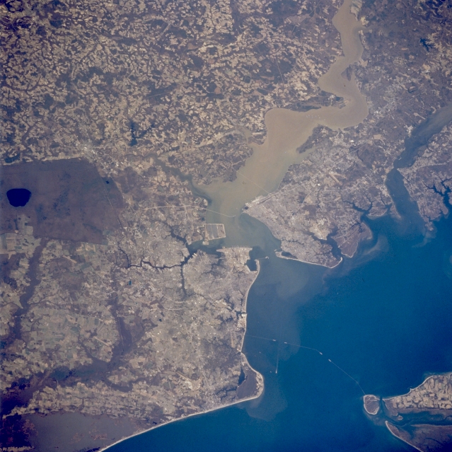 |
| STS062-089-001 JAMES RIVER; NORFOLK, VIRGINIA MARCH, 1994 This west-looking view shows the brown, turbid James River entering Hampton Roads, near the mouth of the Chesapeake Bay (lower right). Hampton Roads is one of the best natural harbors in the U.S. and has been a major anchorage point since colonial times. In March of 1862, Hampton Roads was the site of the Civil War Battle between the Ironclad Monitor and Merrimack. The James River is still navigable for large ships to Richmond, Virginia, 100 miles (160 km) upstream. Norfolk, Virginia is the urban region developed along the southern shore of the James where it enters the Chesapeake Bay. North of Hampton Roads are the smaller cities of Newport News and Hampton. Near the right side of the image is the historic city of Williamsburg, located between the James and York Rivers Other key features in this region include the Dismal Swamp, the dark region at center left. Though much larger in the past, the swamp has been drained and now covers a little more than 600 sq. miles (1554 sq. km). The southern tip of the Delmarva Peninsula is visible near the lower right corner. The linear feature crossing the mouth of the Chesapeake Bay is the Chesapeake Bay Bridge and Tunnel that connects the Delmarva Peninsula (lower right) with the city of Norfolk on the mainland. |
| Images: | All Available Images Low-Resolution 353k |
|
| Mission: | STS062 |
|
| Roll - Frame: | 89 - 1 |
|
| Geographical Name: | USA-VIRGINIA |
|
| Features: | NORFOLK,CHESAPEAKE BAY |
|
| Center Lat x Lon: | 37.0N x 76.5W |
|
| Film Exposure: | N | N=Normal exposure, U=Under exposed, O=Over exposed, F=out of Focus |
| Percentage of Cloud Cover-CLDP: | 0 |
|
| Camera:: | HB |
|
| Camera Tilt: | 41 | LO=Low Oblique, HO=High Oblique, NV=Near Vertical |
| Camera Focal Length: | 250 |
|
| Nadir to Photo Center Direction: | W | The direction from the nadir to the center point, N=North, S=South, E=East, W=West |
| Stereo?: | Y | Y=Yes there is an adjacent picture of the same area, N=No there isn't |
| Orbit Number: | 35 |
|
| Date: | 19940306 | YYYYMMDD |
| Time: | 172714 | GMT HHMMSS |
| Nadir Lat: | 36.0N |
Latitude of suborbital point of spacecraft |
| Nadir Lon: | 74.4W |
Longitude of suborbital point of spacecraft |
| Sun Azimuth: | 187 | Clockwise angle in degrees from north to the sun measured at the nadir point |
| Space Craft Altitude: | 162 | nautical miles |
| Sun Elevation: | 48 | Angle in degrees between the horizon and the sun, measured at the nadir point |
| Land Views: | COAST |
|
| Water Views: | RIVER, SEDIMENT, SWAMP, BAY |
|
| Atmosphere Views: | |
|
| Man Made Views: | URBAN AREA |
|
| City Views: | NORFOLK, NEWPORT NEWS, PORTSMOUTH |
|
Photo is not associated with any sequences | ||
| NASA Home Page |
JSC Home Page |
JSC Digital Image Collection |
Earth Science & Remote Sensing |
|
This service is provided by the International Space Station program and the JSC Earth Science & Remote Sensing Unit, ARES Division, Exploration Integration Science Directorate.

|