Geographic Region: PAKISTAN
Feature: PAN-INDUS RIVER DELTA
|
Geographic Region: PAKISTAN Feature: PAN-INDUS RIVER DELTA |
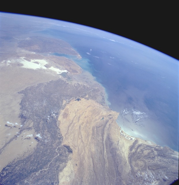 |
| STS062-086-021 Indus River Valley, Pakistan March 1994 Two major physiographic features appear in this south-southeast-looking, high-oblique photograph of southern Pakistan--the Indus River and its floodplain and the southeastern end of the complex Makran Mountain Range. The Indus River and its highly cultivated floodplain produce a variety of grain crops and cotton. Annual rainfall varies from year to year and usually does not exceed 20 inches (50 centimeters); therefore, Pakistan, like Egypt with its Nile River, depends on the Indus River for water. The dark Indus River floodplain is bordered on the east by the Thar Desert (Great Indian Desert) and the highly reflective (white) area in India known as the Great Rann of Kutch (large salt marsh); on the west it is bordered by the complex, folded Makran Mountain Range. Karachi (with an estimated 1990 population of almost 10 million), the major port city on the Arabian Sea and former capital, is located along the western edge of the Indus River floodplain. The large peninsula southeast of the mouths of the Indus River is the Kathiawar Peninsula of India, the home of the only remaining Asian lions. |
| Images: | All Available Images Low-Resolution 80k |
|
| Mission: | STS062 |
|
| Roll - Frame: | 86 - 21 |
|
| Geographical Name: | PAKISTAN |
|
| Features: | PAN-INDUS RIVER DELTA |
|
| Center Lat x Lon: | 25.0N x 68.0E |
|
| Film Exposure: | N | N=Normal exposure, U=Under exposed, O=Over exposed, F=out of Focus |
| Percentage of Cloud Cover-CLDP: | 5 |
|
| Camera:: | HB |
|
| Camera Tilt: | HO | LO=Low Oblique, HO=High Oblique, NV=Near Vertical |
| Camera Focal Length: | 40 |
|
| Nadir to Photo Center Direction: | S | The direction from the nadir to the center point, N=North, S=South, E=East, W=West |
| Stereo?: | Y | Y=Yes there is an adjacent picture of the same area, N=No there isn't |
| Orbit Number: | 61 |
|
| Date: | 19940308 | YYYYMMDD |
| Time: | 084309 | GMT HHMMSS |
| Nadir Lat: | 27.6N |
Latitude of suborbital point of spacecraft |
| Nadir Lon: | 67.4E |
Longitude of suborbital point of spacecraft |
| Sun Azimuth: | 207 | Clockwise angle in degrees from north to the sun measured at the nadir point |
| Space Craft Altitude: | 162 | nautical miles |
| Sun Elevation: | 54 | Angle in degrees between the horizon and the sun, measured at the nadir point |
| Land Views: | COAST, PLAIN, DESERT, MOUNTAIN |
|
| Water Views: | RIVER, DELTA, OCEAN |
|
| Atmosphere Views: | |
|
| Man Made Views: | AGRICULTURE |
|
| City Views: | |
|
Photo is not associated with any sequences | ||
| NASA Home Page |
JSC Home Page |
JSC Digital Image Collection |
Earth Science & Remote Sensing |
|
This service is provided by the International Space Station program and the JSC Earth Science & Remote Sensing Unit, ARES Division, Exploration Integration Science Directorate.

|