
Geographic Region: USA-MISSISSIPPI
Feature: MISSISSIPPI R, AGRICULTURE
|
Geographic Region: USA-MISSISSIPPI Feature: MISSISSIPPI R, AGRICULTURE |
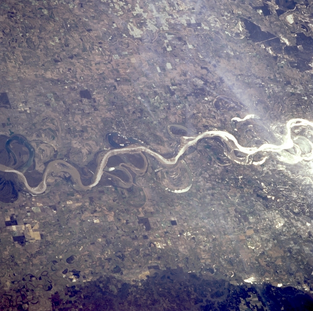 |
| STS062-086-107 Mississippi River Floodplain, Arkansas, U.S.A. March 1994 Sunglint, the sun's reflection off water surfaces, helps to identify exposed water surfaces. Apparent are cultivated agricultural field patterns throughout the flat, fertile Mississippi River floodplain and old meander scars and oxbow lakes along the river's main channel. Greenville (barely discernible) is situated on the east bank of the Mississippi River (near the center of the photograph). The darker area (bottom right) is slightly elevated, forested terrain. |
| Images: | All Available Images Low-Resolution 363k |
|
| Mission: | STS062 |
|
| Roll - Frame: | 86 - 107 |
|
| Geographical Name: | USA-MISSISSIPPI |
|
| Features: | MISSISSIPPI R, AGRICULTURE |
|
| Center Lat x Lon: | 33.5N x 91W |
|
| Film Exposure: | N | N=Normal exposure, U=Under exposed, O=Over exposed, F=out of Focus |
| Percentage of Cloud Cover-CLDP: | 5 |
|
| Camera:: | HB |
|
| Camera Tilt: | 44 | LO=Low Oblique, HO=High Oblique, NV=Near Vertical |
| Camera Focal Length: | 250 |
|
| Nadir to Photo Center Direction: | SE | The direction from the nadir to the center point, N=North, S=South, E=East, W=West |
| Stereo?: | Y | Y=Yes there is an adjacent picture of the same area, N=No there isn't |
| Orbit Number: | 114 |
|
| Date: | 19940311 | YYYYMMDD |
| Time: | 163008 | GMT HHMMSS |
| Nadir Lat: | 34.8N |
Latitude of suborbital point of spacecraft |
| Nadir Lon: | 93.2W |
Longitude of suborbital point of spacecraft |
| Sun Azimuth: | 140 | Clockwise angle in degrees from north to the sun measured at the nadir point |
| Space Craft Altitude: | 161 | nautical miles |
| Sun Elevation: | 43 | Angle in degrees between the horizon and the sun, measured at the nadir point |
| Land Views: | FLOOD PLAIN |
|
| Water Views: | RIVER |
|
| Atmosphere Views: | |
|
| Man Made Views: | AGRICULTURE |
|
| City Views: | |
|
Photo is not associated with any sequences | ||
| NASA Home Page |
JSC Home Page |
JSC Digital Image Collection |
Earth Science & Remote Sensing |
|
This service is provided by the International Space Station program and the JSC Earth Science & Remote Sensing Unit, ARES Division, Exploration Integration Science Directorate.

|