
Geographic Region: USA-NORTH CAROLINA
Feature: CHARLOTTE,CATAWABA R,AGR
|
Geographic Region: USA-NORTH CAROLINA Feature: CHARLOTTE,CATAWABA R,AGR |
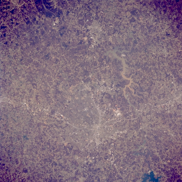 |
| STS062-085-008 Charlotte Area, North Carolina, U.S.A. March 1994 The downtown core, or central business district, of Charlotte can be identified as the concentrated, highly reflective area where several highways converge (slightly below center). Sections of Interstate Highways 85 and 77, shown as thin, light colored lines, are visible as they radiate outward from the downtown core in northeast-southwest and north-south directions, respectively. Charlotte-Douglas International Airport can be identified as the highly reflective feature, located about 5 miles (8 km) west of downtown Charlotte. The serpentine shaped lake southwest of Charlotte is muddy looking Wylie Lake. This lake was created by damming the Catawba River. The southern end of Lake Norman, another reservoir on the Catawba River, is visible in the lower right corner of the picture. The cities of Gastonia (North Carolina), west of Charlotte, and Rock Hill (South Carolina) south of Charlotte can also be identified. |
| Images: | All Available Images Low-Resolution 386k |
|
| Mission: | STS062 |
|
| Roll - Frame: | 85 - 8 |
|
| Geographical Name: | USA-NORTH CAROLINA |
|
| Features: | CHARLOTTE,CATAWABA R,AGR |
|
| Center Lat x Lon: | 35.0N x 81W |
|
| Film Exposure: | N | N=Normal exposure, U=Under exposed, O=Over exposed, F=out of Focus |
| Percentage of Cloud Cover-CLDP: | 0 |
|
| Camera:: | HB |
|
| Camera Tilt: | 15 | LO=Low Oblique, HO=High Oblique, NV=Near Vertical |
| Camera Focal Length: | 250 |
|
| Nadir to Photo Center Direction: | SE | The direction from the nadir to the center point, N=North, S=South, E=East, W=West |
| Stereo?: | Y | Y=Yes there is an adjacent picture of the same area, N=No there isn't |
| Orbit Number: | 51 |
|
| Date: | 19940307 | YYYYMMDD |
| Time: | 173414 | GMT HHMMSS |
| Nadir Lat: | 35.5N |
Latitude of suborbital point of spacecraft |
| Nadir Lon: | 81.5W |
Longitude of suborbital point of spacecraft |
| Sun Azimuth: | 179 | Clockwise angle in degrees from north to the sun measured at the nadir point |
| Space Craft Altitude: | 161 | nautical miles |
| Sun Elevation: | 50 | Angle in degrees between the horizon and the sun, measured at the nadir point |
| Land Views: | |
|
| Water Views: | LAKE, RIVER |
|
| Atmosphere Views: | |
|
| Man Made Views: | HIGHWAY, URBAN AREA, AIRPORT |
|
| City Views: | |
|
Photo is not associated with any sequences | ||
| NASA Home Page |
JSC Home Page |
JSC Digital Image Collection |
Earth Science & Remote Sensing |
|
This service is provided by the International Space Station program and the JSC Earth Science & Remote Sensing Unit, ARES Division, Exploration Integration Science Directorate.

|