
Geographic Region: USA-KENTUCKY
Feature: L. BARKLEY & KENTUCKY L.
|
Geographic Region: USA-KENTUCKY Feature: L. BARKLEY & KENTUCKY L. |
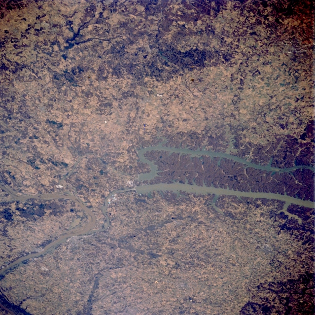 |
| STS062-083-009 Kentucky Lake and Lake Barkley, Kentucky, U.S.A. March 1994 The northern ends of two long reservoirs, Kentucky Lake and Lake Barkley, are visible in this northwest-looking, low-oblique photograph of western Kentucky. Westernmost Kentucky Lake is fed by the Tennessee River; Lake Barkley is part of the Cumberland River drainage basin. Each lake has a dam and channel that allow water to flow into the Ohio River, which makes a U-turn at this location. The heavily wooded peninsula between the lakes is called locally "the land between the lakes." Both lakes are under the aegis of the Tennessee Valley Authority, which was created to provide hydroelectric power, improve navigation of the rivers, and reduce flooding on the Tennessee and Cumberland Rivers and some of their tributaries. Most of the region east of the lakes is hilly; west of the lakes the landscape becomes a plain. |
| Images: | All Available Images Low-Resolution 414k |
|
| Mission: | STS062 |
|
| Roll - Frame: | 83 - 9 |
|
| Geographical Name: | USA-KENTUCKY |
|
| Features: | L. BARKLEY & KENTUCKY L. |
|
| Center Lat x Lon: | 37.0N x 88W |
|
| Film Exposure: | N | N=Normal exposure, U=Under exposed, O=Over exposed, F=out of Focus |
| Percentage of Cloud Cover-CLDP: | 0 |
|
| Camera:: | HB |
|
| Camera Tilt: | 48 | LO=Low Oblique, HO=High Oblique, NV=Near Vertical |
| Camera Focal Length: | 250 |
|
| Nadir to Photo Center Direction: | W | The direction from the nadir to the center point, N=North, S=South, E=East, W=West |
| Stereo?: | Y | Y=Yes there is an adjacent picture of the same area, N=No there isn't |
| Orbit Number: | 18 |
|
| Date: | 19940305 | YYYYMMDD |
| Time: | 154111 | GMT HHMMSS |
| Nadir Lat: | 37.7N |
Latitude of suborbital point of spacecraft |
| Nadir Lon: | 85.1W |
Longitude of suborbital point of spacecraft |
| Sun Azimuth: | 138 | Clockwise angle in degrees from north to the sun measured at the nadir point |
| Space Craft Altitude: | 161 | nautical miles |
| Sun Elevation: | 37 | Angle in degrees between the horizon and the sun, measured at the nadir point |
| Land Views: | HILL |
|
| Water Views: | RIVER, LAKE |
|
| Atmosphere Views: | |
|
| Man Made Views: | |
|
| City Views: | |
|
Photo is not associated with any sequences | ||
| NASA Home Page |
JSC Home Page |
JSC Digital Image Collection |
Earth Science & Remote Sensing |
|
This service is provided by the International Space Station program and the JSC Earth Science & Remote Sensing Unit, ARES Division, Exploration Integration Science Directorate.

|